

Key Insights
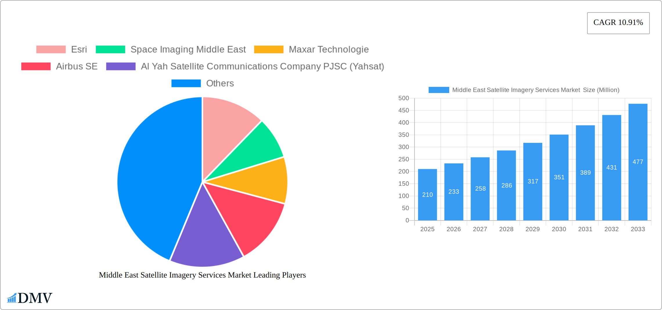
The Middle East Satellite Imagery Services market, valued at $210 million in 2025, is projected to experience robust growth, exhibiting a Compound Annual Growth Rate (CAGR) of 10.91% from 2025 to 2033. This expansion is driven by several key factors. Firstly, increasing government investments in infrastructure development, particularly in construction, transportation, and urban planning, fuel the demand for high-resolution satellite imagery for project monitoring and resource management. Secondly, the burgeoning need for enhanced security and surveillance across the region, including border protection and disaster response, significantly contributes to market growth. Furthermore, the region's focus on sustainable development and environmental conservation necessitates the use of satellite imagery for natural resource management and precision agriculture. The adoption of advanced analytics and AI-powered solutions for processing and interpreting satellite data further enhances the market's potential. Competition in the market is strong, with both international giants like Maxar Technologies and Airbus SE, and regional players such as Yahsat and SARsat Arabia vying for market share.
The market segmentation reveals significant opportunities across various applications and end-users. Geospatial data acquisition and mapping represent a substantial segment, driven by the need for detailed and accurate geographical information for various applications. Similarly, the government sector remains a key end-user, leveraging satellite imagery for numerous initiatives, from urban planning to defense and national security. The construction, transportation, and logistics sectors are also significant contributors, employing satellite imagery for project management, infrastructure monitoring, and route optimization. While the market faces certain challenges, including data security concerns and the need for skilled professionals in data interpretation and analysis, the overall growth trajectory remains exceptionally positive, fueled by technological advancements and sustained government and private sector investment. The forecast period of 2025-2033 promises to be a period of significant expansion for the Middle East Satellite Imagery Services market.
Middle East Satellite Imagery Services Market: A Comprehensive Report (2019-2033)
This insightful report provides a detailed analysis of the Middle East Satellite Imagery Services Market, encompassing market size, growth drivers, key players, and future opportunities. The study period covers 2019-2033, with 2025 as the base and estimated year. We project robust growth, with the market expected to reach xx Million by 2033. This report is essential for stakeholders seeking to understand the dynamics of this rapidly evolving sector and make informed strategic decisions.
Middle East Satellite Imagery Services Market Market Composition & Trends
The Middle East Satellite Imagery Services market exhibits a moderately concentrated landscape, with several major players holding significant market share. Esri, Maxar Technologies, and Airbus SE are among the leading companies, though regional players like Al Yah Satellite Communications Company PJSC (Yahsat) and SARsat Arabia are also gaining traction. The market is driven by increasing demand for geospatial data across various sectors, including government, military, and construction. Innovation is fueled by advancements in satellite technology, improved image processing capabilities, and the growing adoption of AI and machine learning for data analysis. Regulatory frameworks vary across the region, with some countries exhibiting more supportive policies than others. The market experiences competition from alternative geospatial data acquisition methods, including aerial photography and LiDAR.
Market Share Distribution (2025 Estimate):
- Esri: xx%
- Maxar Technologies: xx%
- Airbus SE: xx%
- Al Yahsat: xx%
- Others: xx%
M&A Activity (2019-2024):
- Total deal value: xx Million
- Number of deals: xx
- Average deal size: xx Million
The report further analyzes specific M&A activities and their impact on market consolidation.

Middle East Satellite Imagery Services Market Industry Evolution
The Middle East Satellite Imagery Services market has experienced remarkable growth from 2019 to 2024, driven by a confluence of factors. Significant government investments in infrastructure projects, amplified security concerns across the region, and the widespread adoption of advanced geospatial technologies have all contributed to this expansion. While precise figures are proprietary, the market demonstrated a robust Compound Annual Growth Rate (CAGR) during this period. Looking ahead to 2025-2033, this positive trajectory is expected to continue. The forecast projects sustained growth fueled by several key trends: the emergence of higher-resolution satellite imagery, increasing demand for accurate geospatial data across diverse sectors (including urban planning, agriculture, and resource management), and the accelerating adoption of cloud-based solutions for data storage, processing, and analysis. We project a strong CAGR for the forecast period, reflecting the market's dynamism and potential. Technological advancements, particularly in AI-powered image analysis and the development of more sophisticated, higher-resolution sensors, are key catalysts. The rising demand for real-time data and enhanced analytical capabilities is also reshaping the market landscape, prompting service providers to continuously innovate and deliver advanced solutions. Furthermore, the market is seeing a growing need for customized satellite imagery solutions tailored to the specific needs and emerging applications of diverse end-users.
Leading Regions, Countries, or Segments in Middle East Satellite Imagery Services Market
Within the Middle East, the UAE and Saudi Arabia are currently the leading markets for satellite imagery services, driven by significant investments in infrastructure development, urban planning, and national security initiatives.
By Application:
- Surveillance and Security: This segment is the largest, driven by high demand from governments and military organizations for real-time monitoring and intelligence gathering.
- Geospatial Data Acquisition and Mapping: This segment is experiencing significant growth due to increased demand for accurate and up-to-date maps for various applications such as urban planning and infrastructure development.
By End-User:
- Government: This is the largest end-user segment, accounting for a significant portion of the market revenue, driven by government initiatives for national development and security purposes.
- Military and Defense: This segment exhibits high growth potential, with strong demand for high-resolution imagery for intelligence and operational planning.
Key Drivers:
- Government investment in infrastructure: Massive infrastructure projects in the region are creating strong demand for high-resolution satellite imagery for planning and monitoring.
- Regulatory support: Favorable government regulations supporting the use of satellite imagery for various applications have aided market expansion.
- National Security concerns: Increased emphasis on national security and border protection is fostering strong demand for satellite-based surveillance and intelligence solutions.
Middle East Satellite Imagery Services Market Product Innovations
Recent innovations focus on higher-resolution imagery, improved spectral capabilities (hyperspectral and multispectral), and AI-powered analytics for faster, more accurate data processing. New solutions offer real-time data delivery and customized data packages tailored to specific user requirements. The integration of cloud computing and big data technologies is enhancing the accessibility and usability of satellite imagery, while the development of more user-friendly software platforms is further expanding the market reach.
Propelling Factors for Middle East Satellite Imagery Services Market Growth
Several key factors are driving the expansion of the Middle East Satellite Imagery Services market. Technological advancements, most notably the development of improved sensor technology resulting in higher-resolution imagery with a broader spectral range, are paramount. Government initiatives focused on developing smart cities and modernizing infrastructure, coupled with substantial investments in national security and defense, significantly boost demand for satellite imagery and related services. Furthermore, supportive regulatory environments in several Middle Eastern countries are facilitating growth. For instance, initiatives like the UAE's Vision 2021 have demonstrably spurred the adoption of satellite imagery across a range of applications. This proactive policy environment, combined with technological innovation, is creating a fertile ground for market expansion.
Obstacles in the Middle East Satellite Imagery Services Market Market
High initial investment costs for satellite technology can be a barrier to entry for smaller companies. Data security concerns and regulations related to data privacy can also hinder growth. Competition from established international players and the potential for supply chain disruptions related to satellite hardware and software can impact market dynamics. The complexity of regulatory environments across different countries can create additional challenges for market participants.
Future Opportunities in Middle East Satellite Imagery Services Market
The Middle East Satellite Imagery Services market presents numerous opportunities for growth and innovation. Developing applications for precision agriculture, optimizing resource management through environmental monitoring, and enhancing disaster response capabilities are key areas of expansion. The integration of data from the Internet of Things (IoT) with satellite imagery offers exciting prospects for the creation of novel services that leverage the combined power of these data sources. The growing adoption of cloud-based platforms and the expansion of 5G networks promise to dramatically improve data accessibility and processing capabilities, unlocking new levels of efficiency and analytical sophistication. Furthermore, the market holds substantial potential for expansion into emerging sectors such as renewable energy resource assessment and exploration, offering opportunities for both established players and new entrants.
Major Players in the Middle East Satellite Imagery Services Market Ecosystem
- Esri
- Space Imaging Middle East
- Maxar Technologies
- Airbus SE
- Al Yah Satellite Communications Company PJSC (Yahsat)
- Serco Group plc
- Thales Group
- GEOMAP Consultants
- SARsat Arabia
- Northstar Saudi Arabia
Key Developments in Middle East Satellite Imagery Services Market Industry
- July 2023: Impact Observatory and Planet Labs PBC formed a strategic partnership to leverage AI for enhanced land cover and land use assessment. This collaboration significantly improves the quality and analytical capabilities of available satellite imagery data, offering more valuable insights to clients.
- December 2022: SpaceX successfully launched an Israeli Earth-imaging satellite designed for military security and intelligence applications. This launch represents a significant advancement in regional capabilities and underscores the growing strategic importance of satellite imagery in the Middle East.
- [Add more recent key developments here with dates and brief descriptions. For example, new partnerships, product launches, regulatory changes, or significant investments.]
Strategic Middle East Satellite Imagery Services Market Market Forecast
The Middle East Satellite Imagery Services market is poised for continued strong growth, driven by technological innovation and increasing demand across various sectors. The convergence of satellite imagery with AI and big data analytics will unlock new possibilities, creating significant opportunities for existing and new market entrants. The expanding adoption of satellite imagery for smart city initiatives, environmental management, and national security will ensure substantial market expansion in the coming years.
Middle East Satellite Imagery Services Market Segmentation
-
1. Application
- 1.1. Geospatial Data Acquisition and Mapping
- 1.2. Natural Resource Management
- 1.3. Surveillance and Security
- 1.4. Conservation and Research
- 1.5. Disaster Management
- 1.6. Intelligence
-
2. End-User
- 2.1. Government
- 2.2. Construction
- 2.3. Transportation and Logistics
- 2.4. Military and Defense
- 2.5. Forestry and Agriculture
- 2.6. Other End-Users
-
3. Geography
- 3.1. UAE
- 3.2. Saudi Arabia
Middle East Satellite Imagery Services Market Segmentation By Geography
- 1. UAE
- 2. Saudi Arabia

Middle East Satellite Imagery Services Market REPORT HIGHLIGHTS
| Aspects | Details |
|---|---|
| Study Period | 2019-2033 |
| Base Year | 2024 |
| Estimated Year | 2025 |
| Forecast Period | 2025-2033 |
| Historical Period | 2019-2024 |
| Growth Rate | CAGR of 10.91% from 2019-2033 |
| Segmentation |
|
Table of Contents
- 1. Introduction
- 1.1. Research Scope
- 1.2. Market Segmentation
- 1.3. Research Methodology
- 1.4. Definitions and Assumptions
- 2. Executive Summary
- 2.1. Introduction
- 3. Market Dynamics
- 3.1. Introduction
- 3.2. Market Drivers
- 3.2.1. Increasing Adoption of Location-based Services; Surge in the usage of Satellite data
- 3.3. Market Restrains
- 3.3.1. High-resolution Images Offered by Other Imaging Technologies
- 3.4. Market Trends
- 3.4.1. Increasing Adoption of Location-based Services
- 4. Market Factor Analysis
- 4.1. Porters Five Forces
- 4.2. Supply/Value Chain
- 4.3. PESTEL analysis
- 4.4. Market Entropy
- 4.5. Patent/Trademark Analysis
- 5. Middle East Satellite Imagery Services Market Analysis, Insights and Forecast, 2019-2031
- 5.1. Market Analysis, Insights and Forecast - by Application
- 5.1.1. Geospatial Data Acquisition and Mapping
- 5.1.2. Natural Resource Management
- 5.1.3. Surveillance and Security
- 5.1.4. Conservation and Research
- 5.1.5. Disaster Management
- 5.1.6. Intelligence
- 5.2. Market Analysis, Insights and Forecast - by End-User
- 5.2.1. Government
- 5.2.2. Construction
- 5.2.3. Transportation and Logistics
- 5.2.4. Military and Defense
- 5.2.5. Forestry and Agriculture
- 5.2.6. Other End-Users
- 5.3. Market Analysis, Insights and Forecast - by Geography
- 5.3.1. UAE
- 5.3.2. Saudi Arabia
- 5.4. Market Analysis, Insights and Forecast - by Region
- 5.4.1. UAE
- 5.4.2. Saudi Arabia
- 5.1. Market Analysis, Insights and Forecast - by Application
- 6. UAE Middle East Satellite Imagery Services Market Analysis, Insights and Forecast, 2019-2031
- 6.1. Market Analysis, Insights and Forecast - by Application
- 6.1.1. Geospatial Data Acquisition and Mapping
- 6.1.2. Natural Resource Management
- 6.1.3. Surveillance and Security
- 6.1.4. Conservation and Research
- 6.1.5. Disaster Management
- 6.1.6. Intelligence
- 6.2. Market Analysis, Insights and Forecast - by End-User
- 6.2.1. Government
- 6.2.2. Construction
- 6.2.3. Transportation and Logistics
- 6.2.4. Military and Defense
- 6.2.5. Forestry and Agriculture
- 6.2.6. Other End-Users
- 6.3. Market Analysis, Insights and Forecast - by Geography
- 6.3.1. UAE
- 6.3.2. Saudi Arabia
- 6.1. Market Analysis, Insights and Forecast - by Application
- 7. Saudi Arabia Middle East Satellite Imagery Services Market Analysis, Insights and Forecast, 2019-2031
- 7.1. Market Analysis, Insights and Forecast - by Application
- 7.1.1. Geospatial Data Acquisition and Mapping
- 7.1.2. Natural Resource Management
- 7.1.3. Surveillance and Security
- 7.1.4. Conservation and Research
- 7.1.5. Disaster Management
- 7.1.6. Intelligence
- 7.2. Market Analysis, Insights and Forecast - by End-User
- 7.2.1. Government
- 7.2.2. Construction
- 7.2.3. Transportation and Logistics
- 7.2.4. Military and Defense
- 7.2.5. Forestry and Agriculture
- 7.2.6. Other End-Users
- 7.3. Market Analysis, Insights and Forecast - by Geography
- 7.3.1. UAE
- 7.3.2. Saudi Arabia
- 7.1. Market Analysis, Insights and Forecast - by Application
- 8. United Arab Emirates Middle East Satellite Imagery Services Market Analysis, Insights and Forecast, 2019-2031
- 9. Saudi Arabia Middle East Satellite Imagery Services Market Analysis, Insights and Forecast, 2019-2031
- 10. Qatar Middle East Satellite Imagery Services Market Analysis, Insights and Forecast, 2019-2031
- 11. Israel Middle East Satellite Imagery Services Market Analysis, Insights and Forecast, 2019-2031
- 12. Egypt Middle East Satellite Imagery Services Market Analysis, Insights and Forecast, 2019-2031
- 13. Oman Middle East Satellite Imagery Services Market Analysis, Insights and Forecast, 2019-2031
- 14. Rest of Middle East Middle East Satellite Imagery Services Market Analysis, Insights and Forecast, 2019-2031
- 15. Competitive Analysis
- 15.1. Market Share Analysis 2024
- 15.2. Company Profiles
- 15.2.1 Esri
- 15.2.1.1. Overview
- 15.2.1.2. Products
- 15.2.1.3. SWOT Analysis
- 15.2.1.4. Recent Developments
- 15.2.1.5. Financials (Based on Availability)
- 15.2.2 Space Imaging Middle East
- 15.2.2.1. Overview
- 15.2.2.2. Products
- 15.2.2.3. SWOT Analysis
- 15.2.2.4. Recent Developments
- 15.2.2.5. Financials (Based on Availability)
- 15.2.3 Maxar Technologie
- 15.2.3.1. Overview
- 15.2.3.2. Products
- 15.2.3.3. SWOT Analysis
- 15.2.3.4. Recent Developments
- 15.2.3.5. Financials (Based on Availability)
- 15.2.4 Airbus SE
- 15.2.4.1. Overview
- 15.2.4.2. Products
- 15.2.4.3. SWOT Analysis
- 15.2.4.4. Recent Developments
- 15.2.4.5. Financials (Based on Availability)
- 15.2.5 Al Yah Satellite Communications Company PJSC (Yahsat)
- 15.2.5.1. Overview
- 15.2.5.2. Products
- 15.2.5.3. SWOT Analysis
- 15.2.5.4. Recent Developments
- 15.2.5.5. Financials (Based on Availability)
- 15.2.6 Serco Group plc
- 15.2.6.1. Overview
- 15.2.6.2. Products
- 15.2.6.3. SWOT Analysis
- 15.2.6.4. Recent Developments
- 15.2.6.5. Financials (Based on Availability)
- 15.2.7 Thales Group
- 15.2.7.1. Overview
- 15.2.7.2. Products
- 15.2.7.3. SWOT Analysis
- 15.2.7.4. Recent Developments
- 15.2.7.5. Financials (Based on Availability)
- 15.2.8 GEOMAP Consultants
- 15.2.8.1. Overview
- 15.2.8.2. Products
- 15.2.8.3. SWOT Analysis
- 15.2.8.4. Recent Developments
- 15.2.8.5. Financials (Based on Availability)
- 15.2.9 SARsat Arabia
- 15.2.9.1. Overview
- 15.2.9.2. Products
- 15.2.9.3. SWOT Analysis
- 15.2.9.4. Recent Developments
- 15.2.9.5. Financials (Based on Availability)
- 15.2.10 Northstar Saudi Arabia
- 15.2.10.1. Overview
- 15.2.10.2. Products
- 15.2.10.3. SWOT Analysis
- 15.2.10.4. Recent Developments
- 15.2.10.5. Financials (Based on Availability)
- 15.2.1 Esri
List of Figures
- Figure 1: Middle East Satellite Imagery Services Market Revenue Breakdown (Million, %) by Product 2024 & 2032
- Figure 2: Middle East Satellite Imagery Services Market Share (%) by Company 2024
List of Tables
- Table 1: Middle East Satellite Imagery Services Market Revenue Million Forecast, by Region 2019 & 2032
- Table 2: Middle East Satellite Imagery Services Market Volume K Unit Forecast, by Region 2019 & 2032
- Table 3: Middle East Satellite Imagery Services Market Revenue Million Forecast, by Application 2019 & 2032
- Table 4: Middle East Satellite Imagery Services Market Volume K Unit Forecast, by Application 2019 & 2032
- Table 5: Middle East Satellite Imagery Services Market Revenue Million Forecast, by End-User 2019 & 2032
- Table 6: Middle East Satellite Imagery Services Market Volume K Unit Forecast, by End-User 2019 & 2032
- Table 7: Middle East Satellite Imagery Services Market Revenue Million Forecast, by Geography 2019 & 2032
- Table 8: Middle East Satellite Imagery Services Market Volume K Unit Forecast, by Geography 2019 & 2032
- Table 9: Middle East Satellite Imagery Services Market Revenue Million Forecast, by Region 2019 & 2032
- Table 10: Middle East Satellite Imagery Services Market Volume K Unit Forecast, by Region 2019 & 2032
- Table 11: Middle East Satellite Imagery Services Market Revenue Million Forecast, by Country 2019 & 2032
- Table 12: Middle East Satellite Imagery Services Market Volume K Unit Forecast, by Country 2019 & 2032
- Table 13: United Arab Emirates Middle East Satellite Imagery Services Market Revenue (Million) Forecast, by Application 2019 & 2032
- Table 14: United Arab Emirates Middle East Satellite Imagery Services Market Volume (K Unit) Forecast, by Application 2019 & 2032
- Table 15: Saudi Arabia Middle East Satellite Imagery Services Market Revenue (Million) Forecast, by Application 2019 & 2032
- Table 16: Saudi Arabia Middle East Satellite Imagery Services Market Volume (K Unit) Forecast, by Application 2019 & 2032
- Table 17: Qatar Middle East Satellite Imagery Services Market Revenue (Million) Forecast, by Application 2019 & 2032
- Table 18: Qatar Middle East Satellite Imagery Services Market Volume (K Unit) Forecast, by Application 2019 & 2032
- Table 19: Israel Middle East Satellite Imagery Services Market Revenue (Million) Forecast, by Application 2019 & 2032
- Table 20: Israel Middle East Satellite Imagery Services Market Volume (K Unit) Forecast, by Application 2019 & 2032
- Table 21: Egypt Middle East Satellite Imagery Services Market Revenue (Million) Forecast, by Application 2019 & 2032
- Table 22: Egypt Middle East Satellite Imagery Services Market Volume (K Unit) Forecast, by Application 2019 & 2032
- Table 23: Oman Middle East Satellite Imagery Services Market Revenue (Million) Forecast, by Application 2019 & 2032
- Table 24: Oman Middle East Satellite Imagery Services Market Volume (K Unit) Forecast, by Application 2019 & 2032
- Table 25: Rest of Middle East Middle East Satellite Imagery Services Market Revenue (Million) Forecast, by Application 2019 & 2032
- Table 26: Rest of Middle East Middle East Satellite Imagery Services Market Volume (K Unit) Forecast, by Application 2019 & 2032
- Table 27: Middle East Satellite Imagery Services Market Revenue Million Forecast, by Application 2019 & 2032
- Table 28: Middle East Satellite Imagery Services Market Volume K Unit Forecast, by Application 2019 & 2032
- Table 29: Middle East Satellite Imagery Services Market Revenue Million Forecast, by End-User 2019 & 2032
- Table 30: Middle East Satellite Imagery Services Market Volume K Unit Forecast, by End-User 2019 & 2032
- Table 31: Middle East Satellite Imagery Services Market Revenue Million Forecast, by Geography 2019 & 2032
- Table 32: Middle East Satellite Imagery Services Market Volume K Unit Forecast, by Geography 2019 & 2032
- Table 33: Middle East Satellite Imagery Services Market Revenue Million Forecast, by Country 2019 & 2032
- Table 34: Middle East Satellite Imagery Services Market Volume K Unit Forecast, by Country 2019 & 2032
- Table 35: Middle East Satellite Imagery Services Market Revenue Million Forecast, by Application 2019 & 2032
- Table 36: Middle East Satellite Imagery Services Market Volume K Unit Forecast, by Application 2019 & 2032
- Table 37: Middle East Satellite Imagery Services Market Revenue Million Forecast, by End-User 2019 & 2032
- Table 38: Middle East Satellite Imagery Services Market Volume K Unit Forecast, by End-User 2019 & 2032
- Table 39: Middle East Satellite Imagery Services Market Revenue Million Forecast, by Geography 2019 & 2032
- Table 40: Middle East Satellite Imagery Services Market Volume K Unit Forecast, by Geography 2019 & 2032
- Table 41: Middle East Satellite Imagery Services Market Revenue Million Forecast, by Country 2019 & 2032
- Table 42: Middle East Satellite Imagery Services Market Volume K Unit Forecast, by Country 2019 & 2032
Frequently Asked Questions
1. What is the projected Compound Annual Growth Rate (CAGR) of the Middle East Satellite Imagery Services Market ?
The projected CAGR is approximately 10.91%.
2. Which companies are prominent players in the Middle East Satellite Imagery Services Market ?
Key companies in the market include Esri, Space Imaging Middle East, Maxar Technologie, Airbus SE, Al Yah Satellite Communications Company PJSC (Yahsat), Serco Group plc, Thales Group, GEOMAP Consultants, SARsat Arabia, Northstar Saudi Arabia.
3. What are the main segments of the Middle East Satellite Imagery Services Market ?
The market segments include Application, End-User, Geography.
4. Can you provide details about the market size?
The market size is estimated to be USD 0.21 Million as of 2022.
5. What are some drivers contributing to market growth?
Increasing Adoption of Location-based Services; Surge in the usage of Satellite data.
6. What are the notable trends driving market growth?
Increasing Adoption of Location-based Services.
7. Are there any restraints impacting market growth?
High-resolution Images Offered by Other Imaging Technologies.
8. Can you provide examples of recent developments in the market?
July 2023: Impact Obsеrvatory, a prominеnt US-basеd spacе obsеrvation systеm company, forgеd a stratеgic partnеrship with Planеt Labs PBC, a global providеr of daily data and insights. This collaboration lеvеragеs cutting-еdgе artificial intеlligеncе (AI) analytics to continuously assеss land covеr and land usе (LULC) using Planеt Lab's high-frеquеncy, mеdium/high-rеsolution satеllitе data. Thе primary objеctivе of this partnеrship is to providе customеrs with supеrior spacе-basеd global mapping and monitoring solutions, surpassing thе capabilitiеs of publicly availablе satеllitе imagеry.
9. What pricing options are available for accessing the report?
Pricing options include single-user, multi-user, and enterprise licenses priced at USD 4750, USD 5250, and USD 8750 respectively.
10. Is the market size provided in terms of value or volume?
The market size is provided in terms of value, measured in Million and volume, measured in K Unit.
11. Are there any specific market keywords associated with the report?
Yes, the market keyword associated with the report is "Middle East Satellite Imagery Services Market ," which aids in identifying and referencing the specific market segment covered.
12. How do I determine which pricing option suits my needs best?
The pricing options vary based on user requirements and access needs. Individual users may opt for single-user licenses, while businesses requiring broader access may choose multi-user or enterprise licenses for cost-effective access to the report.
13. Are there any additional resources or data provided in the Middle East Satellite Imagery Services Market report?
While the report offers comprehensive insights, it's advisable to review the specific contents or supplementary materials provided to ascertain if additional resources or data are available.
14. How can I stay updated on further developments or reports in the Middle East Satellite Imagery Services Market ?
To stay informed about further developments, trends, and reports in the Middle East Satellite Imagery Services Market , consider subscribing to industry newsletters, following relevant companies and organizations, or regularly checking reputable industry news sources and publications.
Methodology
Step 1 - Identification of Relevant Samples Size from Population Database
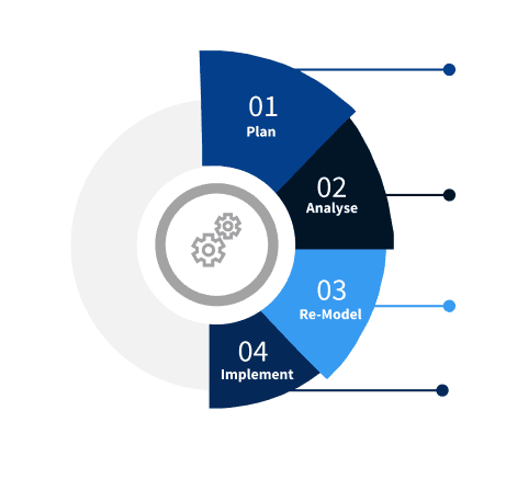


Step 2 - Approaches for Defining Global Market Size (Value, Volume* & Price*)

Note*: In applicable scenarios
Step 3 - Data Sources
Primary Research
- Web Analytics
- Survey Reports
- Research Institute
- Latest Research Reports
- Opinion Leaders
Secondary Research
- Annual Reports
- White Paper
- Latest Press Release
- Industry Association
- Paid Database
- Investor Presentations

Step 4 - Data Triangulation
Involves using different sources of information in order to increase the validity of a study
These sources are likely to be stakeholders in a program - participants, other researchers, program staff, other community members, and so on.
Then we put all data in single framework & apply various statistical tools to find out the dynamic on the market.
During the analysis stage, feedback from the stakeholder groups would be compared to determine areas of agreement as well as areas of divergence
