

Key Insights
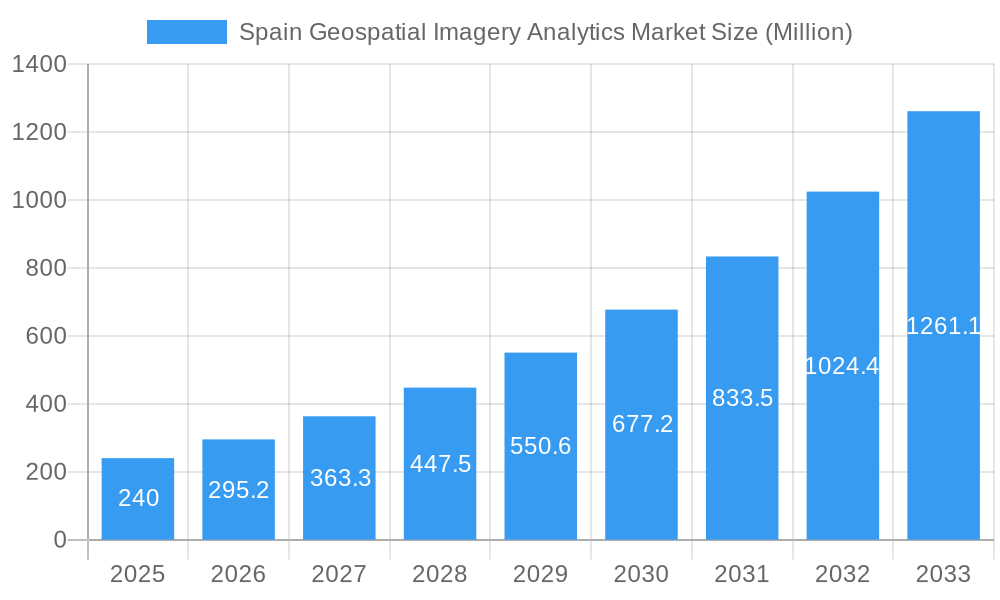
The Spain Geospatial Imagery Analytics market is experiencing robust growth, projected to reach €0.24 million in 2025 and maintain a Compound Annual Growth Rate (CAGR) of 23% from 2025 to 2033. This expansion is driven by increasing adoption of advanced analytics in various sectors, including insurance (for risk assessment and claims processing), agriculture (precision farming and yield optimization), and defense and security (surveillance and intelligence gathering). The market is further fueled by technological advancements in image processing, improved sensor technology leading to higher resolution imagery, and the increasing availability of cloud-based geospatial analytics platforms, offering scalability and cost-effectiveness to both SMEs and large enterprises. Government initiatives promoting digitalization and smart city development also contribute significantly to market growth.
Spain Geospatial Imagery Analytics Market Market Size (In Million)
However, challenges exist. Data privacy concerns and the need for robust cybersecurity measures represent key restraints. Furthermore, the high initial investment cost for advanced software and hardware can be a barrier for entry for smaller companies. Despite these challenges, the long-term outlook remains positive, driven by the continuous innovation in analytics techniques, expanding applications across sectors, and the increasing availability of affordable high-resolution imagery from satellites and drones. The market segmentation indicates strong potential across deployment modes (cloud solutions are expected to grow faster than on-premise), organization sizes (large enterprises currently dominate but SME adoption is growing), and various vertical applications, suggesting diverse avenues for future market penetration and expansion within Spain.
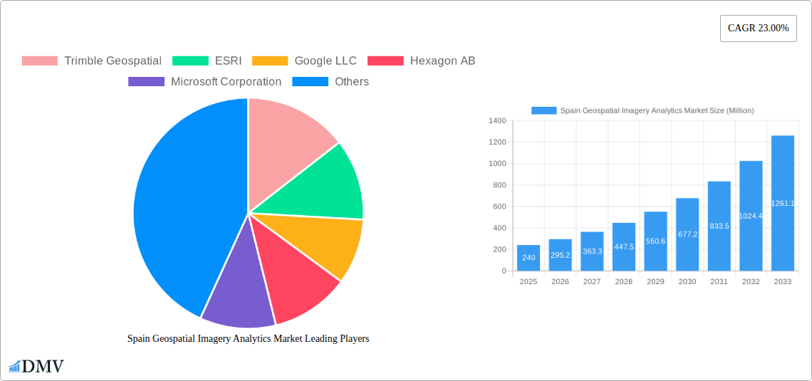
Spain Geospatial Imagery Analytics Market Company Market Share
Spain Geospatial Imagery Analytics Market: A Comprehensive Report (2019-2033)
This insightful report provides a detailed analysis of the Spain Geospatial Imagery Analytics Market, offering a comprehensive overview of its current state, future trajectory, and key players. The study period covers 2019-2033, with 2025 as the base and estimated year, and a forecast period of 2025-2033. The report delves into market segmentation, technological advancements, competitive landscape, and growth opportunities, providing invaluable insights for stakeholders seeking to navigate this dynamic market. The market is expected to reach xx Million by 2033.
Spain Geospatial Imagery Analytics Market Composition & Trends
This section provides a granular analysis of the Spanish geospatial imagery analytics market, evaluating its structure, driving forces, and regulatory environment. We examine market concentration, identifying key players and their respective market shares. The report also explores innovation catalysts, such as advancements in AI and cloud computing, and their impact on market growth. Furthermore, it analyzes the regulatory landscape, including relevant policies and their influence on market dynamics. Substitute products and their competitive pressures are assessed, along with a detailed profile of end-users across various sectors. Finally, the report reviews recent mergers and acquisitions (M&A) activity within the market, including deal values and their strategic implications.
- Market Share Distribution: Trimble Geospatial, ESRI, and Hexagon AB hold a significant portion of the market share, with Google LLC and Microsoft Corporation emerging as strong competitors. Precise market share figures will be provided in the complete report.
- M&A Activity: The report will detail completed and anticipated M&A transactions, analyzing their impact on market consolidation and competitive dynamics. The total value of M&A deals in the historical period (2019-2024) is estimated at xx Million.
Spain Geospatial Imagery Analytics Market Industry Evolution
This section traces the evolution of the Spain Geospatial Imagery Analytics Market, charting its growth trajectory from 2019 to 2033. The analysis will incorporate detailed data points, including compound annual growth rates (CAGRs) and adoption rates for various technologies. We examine the influence of technological advancements, such as the rise of AI-powered image analysis and the increasing adoption of cloud-based solutions, on market expansion. The evolving demands of end-users across different sectors will be explored, along with their impact on market segmentation and product development. The analysis will also incorporate a deep dive into market size and value changes over time, providing projections for the forecast period.
Leading Regions, Countries, or Segments in Spain Geospatial Imagery Analytics Market
This section identifies the dominant regions, countries, and market segments within Spain's Geospatial Imagery Analytics Market. We analyze factors contributing to their leadership, including investment trends, regulatory support, and the concentration of key players.
By Type: Imagery analytics is currently the dominant segment, with video analytics expected to show significant growth in the forecast period.
By Deployment Mode: The cloud segment enjoys significant popularity due to scalability and cost-effectiveness.
By Organization Size: Large Enterprises are the major consumers of geospatial imagery analytics, driven by their need for large-scale data processing and analysis.
By Vertical: The Government and Defense & Security sectors represent substantial market segments, followed by the Engineering & Construction and Environmental Monitoring sectors. The Insurance sector is showing promising growth potential.
Key Drivers (Examples):
- Government Initiatives: Government funding for infrastructure projects and environmental monitoring programs significantly boosts demand for geospatial imagery analytics.
- Technological Advancements: AI and Machine Learning integration accelerates processing and analysis of large datasets.
- Increased Private Investment: Private sector investment in precision agriculture and smart city initiatives fuels market growth.
Spain Geospatial Imagery Analytics Market Product Innovations
This section highlights recent product innovations within the Spanish geospatial imagery analytics market, emphasizing their unique selling propositions (USPs) and technological advancements. We detail new applications and improved performance metrics of existing and emerging technologies, showcasing how they improve efficiency and accuracy in data processing and analysis. For instance, advancements in AI-powered object detection and image classification are significantly improving the accuracy and speed of analysis.
Propelling Factors for Spain Geospatial Imagery Analytics Market Growth
Several key factors drive the growth of the Spain Geospatial Imagery Analytics Market. Technological advancements, such as improved sensor technology, AI-powered analytics, and cloud computing, are enabling more efficient and accurate data processing. Economic factors, including increasing government investments in infrastructure projects and private sector investment in various industries, also fuel market expansion. Finally, supportive regulatory policies encouraging the adoption of advanced technologies contribute significantly to market growth.
Obstacles in the Spain Geospatial Imagery Analytics Market
The Spain Geospatial Imagery Analytics market faces challenges. Data privacy regulations and cybersecurity concerns present regulatory hurdles. Supply chain disruptions impacting the availability of hardware and software components can cause delays and cost increases. Intense competition among established players and the emergence of new entrants creates competitive pressures. These factors can impact market growth negatively. Estimates of quantifiable impacts will be included in the full report.
Future Opportunities in Spain Geospatial Imagery Analytics Market
The future of the Spain Geospatial Imagery Analytics Market holds significant opportunities. Expansion into new markets like precision agriculture and smart cities presents growth potential. The development of innovative technologies, such as 3D modeling and virtual reality applications, will create new market segments. Increasing adoption of AI and machine learning will further enhance efficiency and accuracy of analysis. These trends are projected to drive the market towards higher growth in the coming years.
Major Players in the Spain Geospatial Imagery Analytics Market Ecosystem
Key Developments in Spain Geospatial Imagery Analytics Market Industry
- July 2023: Partnership between Databricks and Esri integrates spatial analytics capabilities into the Databricks Lakehouse Platform, enhancing data analysis for users. This development boosts the capabilities of existing platforms, improving efficiency and market adoption of spatial analytics.
- June 2023: Meta Platforms' release of I-JEPA, a human-like AI model for image analysis, promises superior accuracy in image completion and analysis. This advancement improves the accuracy and efficiency of image processing and analysis.
Strategic Spain Geospatial Imagery Analytics Market Forecast
The Spain Geospatial Imagery Analytics Market is poised for continued growth, driven by technological innovation, increasing government investment, and expanding applications across various sectors. The market's future potential is substantial, with the adoption of advanced analytics and cloud-based solutions expected to drive significant expansion. The integration of AI and machine learning will enhance efficiency and accuracy, further stimulating market growth. The report provides a detailed forecast, including market size and segmentation projections, to guide strategic decision-making.
Spain Geospatial Imagery Analytics Market Segmentation
-
1. Type
- 1.1. Imagery Analytics
- 1.2. Video Analytics
-
2. Deployment Mode
- 2.1. On Premise
- 2.2. Cloud
-
3. Organization Size
- 3.1. SMEs
- 3.2. Large Enterprises
-
4. Vericals
- 4.1. Insurance
- 4.2. Agriculture
- 4.3. Defense and Security
- 4.4. Environmental Monitoring
- 4.5. Engineeting & Construction
- 4.6. Government
- 4.7. Others
Spain Geospatial Imagery Analytics Market Segmentation By Geography
- 1. Spain
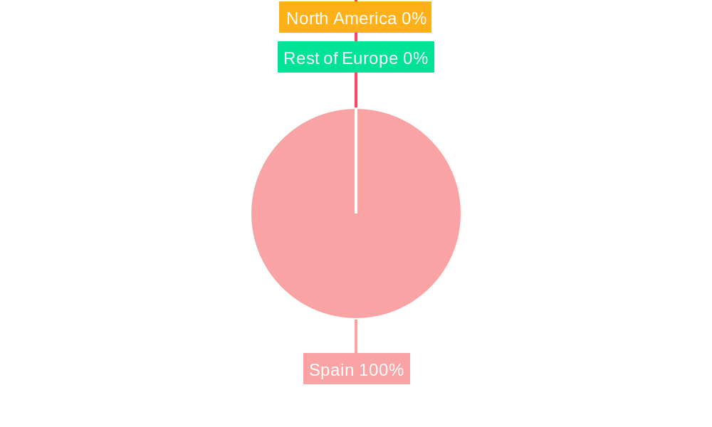
Spain Geospatial Imagery Analytics Market Regional Market Share
Geographic Coverage of Spain Geospatial Imagery Analytics Market
Spain Geospatial Imagery Analytics Market REPORT HIGHLIGHTS
| Aspects | Details |
|---|---|
| Study Period | 2020-2034 |
| Base Year | 2025 |
| Estimated Year | 2026 |
| Forecast Period | 2026-2034 |
| Historical Period | 2020-2025 |
| Growth Rate | CAGR of 23.00% from 2020-2034 |
| Segmentation |
|
Table of Contents
- 1. Introduction
- 1.1. Research Scope
- 1.2. Market Segmentation
- 1.3. Research Objective
- 1.4. Definitions and Assumptions
- 2. Executive Summary
- 2.1. Market Snapshot
- 3. Market Dynamics
- 3.1. Market Drivers
- 3.2. Market Restrains
- 3.3. Market Trends
- 3.4. Market Opportunities
- 4. Market Factor Analysis
- 4.1. Porters Five Forces
- 4.1.1. Bargaining Power of Suppliers
- 4.1.2. Bargaining Power of Buyers
- 4.1.3. Threat of New Entrants
- 4.1.4. Threat of Substitutes
- 4.1.5. Competitive Rivalry
- 4.2. PESTEL analysis
- 4.3. BCG Analysis
- 4.3.1. Stars (High Growth, High Market Share)
- 4.3.2. Cash Cows (Low Growth, High Market Share)
- 4.3.3. Question Mark (High Growth, Low Market Share)
- 4.3.4. Dogs (Low Growth, Low Market Share)
- 4.4. Ansoff Matrix Analysis
- 4.5. Supply Chain Analysis
- 4.6. Regulatory Landscape
- 4.7. Current Market Potential and Opportunity Assessment (TAM–SAM–SOM Framework)
- 4.8. DMV Analyst Note
- 4.1. Porters Five Forces
- 5. Market Analysis, Insights and Forecast 2021-2033
- 5.1. Market Analysis, Insights and Forecast - by Type
- 5.1.1. Imagery Analytics
- 5.1.2. Video Analytics
- 5.2. Market Analysis, Insights and Forecast - by Deployment Mode
- 5.2.1. On Premise
- 5.2.2. Cloud
- 5.3. Market Analysis, Insights and Forecast - by Organization Size
- 5.3.1. SMEs
- 5.3.2. Large Enterprises
- 5.4. Market Analysis, Insights and Forecast - by Vericals
- 5.4.1. Insurance
- 5.4.2. Agriculture
- 5.4.3. Defense and Security
- 5.4.4. Environmental Monitoring
- 5.4.5. Engineeting & Construction
- 5.4.6. Government
- 5.4.7. Others
- 5.5. Market Analysis, Insights and Forecast - by Region
- 5.5.1. Spain
- 5.1. Market Analysis, Insights and Forecast - by Type
- 6. Spain Geospatial Imagery Analytics Market Analysis, Insights and Forecast, 2021-2033
- 6.1. Market Analysis, Insights and Forecast - by Type
- 6.1.1. Imagery Analytics
- 6.1.2. Video Analytics
- 6.2. Market Analysis, Insights and Forecast - by Deployment Mode
- 6.2.1. On Premise
- 6.2.2. Cloud
- 6.3. Market Analysis, Insights and Forecast - by Organization Size
- 6.3.1. SMEs
- 6.3.2. Large Enterprises
- 6.4. Market Analysis, Insights and Forecast - by Vericals
- 6.4.1. Insurance
- 6.4.2. Agriculture
- 6.4.3. Defense and Security
- 6.4.4. Environmental Monitoring
- 6.4.5. Engineeting & Construction
- 6.4.6. Government
- 6.4.7. Others
- 6.1. Market Analysis, Insights and Forecast - by Type
- 7. Competitive Analysis
- 7.1. Company Profiles
- 7.1.1 Trimble Geospatial
- 7.1.1.1. Company Overview
- 7.1.1.2. Products
- 7.1.1.3. Company Financials
- 7.1.1.4. SWOT Analysis
- 7.1.2 ESRI
- 7.1.2.1. Company Overview
- 7.1.2.2. Products
- 7.1.2.3. Company Financials
- 7.1.2.4. SWOT Analysis
- 7.1.3 Google LLC
- 7.1.3.1. Company Overview
- 7.1.3.2. Products
- 7.1.3.3. Company Financials
- 7.1.3.4. SWOT Analysis
- 7.1.4 Hexagon AB
- 7.1.4.1. Company Overview
- 7.1.4.2. Products
- 7.1.4.3. Company Financials
- 7.1.4.4. SWOT Analysis
- 7.1.5 Microsoft Corporation
- 7.1.5.1. Company Overview
- 7.1.5.2. Products
- 7.1.5.3. Company Financials
- 7.1.5.4. SWOT Analysis
- 7.1.6 OrbitalEOS
- 7.1.6.1. Company Overview
- 7.1.6.2. Products
- 7.1.6.3. Company Financials
- 7.1.6.4. SWOT Analysis
- 7.1.7 Oracle Corporation
- 7.1.7.1. Company Overview
- 7.1.7.2. Products
- 7.1.7.3. Company Financials
- 7.1.7.4. SWOT Analysis
- 7.1.8 L3 Harris Corporation
- 7.1.8.1. Company Overview
- 7.1.8.2. Products
- 7.1.8.3. Company Financials
- 7.1.8.4. SWOT Analysis
- 7.1.1 Trimble Geospatial
- 7.2. Market Entropy
- 7.2.1 Company's Key Areas Served
- 7.2.2 Recent Developments
- 7.3. Company Market Share Analysis 2025
- 7.3.1 Top 5 Companies Market Share Analysis
- 7.3.2 Top 3 Companies Market Share Analysis
- 7.4. List of Potential Customers
- 8. Research Methodology
List of Figures
- Figure 1: Spain Geospatial Imagery Analytics Market Revenue Breakdown (Million, %) by Product 2025 & 2033
- Figure 2: Spain Geospatial Imagery Analytics Market Share (%) by Company 2025
List of Tables
- Table 1: Spain Geospatial Imagery Analytics Market Revenue Million Forecast, by Type 2020 & 2033
- Table 2: Spain Geospatial Imagery Analytics Market Volume K Unit Forecast, by Type 2020 & 2033
- Table 3: Spain Geospatial Imagery Analytics Market Revenue Million Forecast, by Deployment Mode 2020 & 2033
- Table 4: Spain Geospatial Imagery Analytics Market Volume K Unit Forecast, by Deployment Mode 2020 & 2033
- Table 5: Spain Geospatial Imagery Analytics Market Revenue Million Forecast, by Organization Size 2020 & 2033
- Table 6: Spain Geospatial Imagery Analytics Market Volume K Unit Forecast, by Organization Size 2020 & 2033
- Table 7: Spain Geospatial Imagery Analytics Market Revenue Million Forecast, by Vericals 2020 & 2033
- Table 8: Spain Geospatial Imagery Analytics Market Volume K Unit Forecast, by Vericals 2020 & 2033
- Table 9: Spain Geospatial Imagery Analytics Market Revenue Million Forecast, by Region 2020 & 2033
- Table 10: Spain Geospatial Imagery Analytics Market Volume K Unit Forecast, by Region 2020 & 2033
- Table 11: Spain Geospatial Imagery Analytics Market Revenue Million Forecast, by Type 2020 & 2033
- Table 12: Spain Geospatial Imagery Analytics Market Volume K Unit Forecast, by Type 2020 & 2033
- Table 13: Spain Geospatial Imagery Analytics Market Revenue Million Forecast, by Deployment Mode 2020 & 2033
- Table 14: Spain Geospatial Imagery Analytics Market Volume K Unit Forecast, by Deployment Mode 2020 & 2033
- Table 15: Spain Geospatial Imagery Analytics Market Revenue Million Forecast, by Organization Size 2020 & 2033
- Table 16: Spain Geospatial Imagery Analytics Market Volume K Unit Forecast, by Organization Size 2020 & 2033
- Table 17: Spain Geospatial Imagery Analytics Market Revenue Million Forecast, by Vericals 2020 & 2033
- Table 18: Spain Geospatial Imagery Analytics Market Volume K Unit Forecast, by Vericals 2020 & 2033
- Table 19: Spain Geospatial Imagery Analytics Market Revenue Million Forecast, by Country 2020 & 2033
- Table 20: Spain Geospatial Imagery Analytics Market Volume K Unit Forecast, by Country 2020 & 2033
Frequently Asked Questions
1. What is the projected Compound Annual Growth Rate (CAGR) of the Spain Geospatial Imagery Analytics Market?
The projected CAGR is approximately 23.00%.
2. Which companies are prominent players in the Spain Geospatial Imagery Analytics Market?
Key companies in the market include Trimble Geospatial, ESRI, Google LLC, Hexagon AB, Microsoft Corporation, OrbitalEOS, Oracle Corporation, L3 Harris Corporation.
3. What are the main segments of the Spain Geospatial Imagery Analytics Market?
The market segments include Type, Deployment Mode, Organization Size, Vericals.
4. Can you provide details about the market size?
The market size is estimated to be USD 0.24 Million as of 2022.
5. What are some drivers contributing to market growth?
Increasing Adoption of Location-based Services; Increasing Demand for Safe and Secure Mining Operations.
6. What are the notable trends driving market growth?
Cloud Segment is Expected to Hold a Significant Share of the Market.
7. Are there any restraints impacting market growth?
Legal and Regulatory Hurdles.
8. Can you provide examples of recent developments in the market?
July 2023: Databricks is the provider of a big data tool named Databricks Lakehouse Platform, which merges data science, data engineering, machine learning, and analytics within a single platform. To provide even more valuable insights to data scientists, spatial analytics is often added to the mix to put large amounts of data in the proper context. A new partnership with Esri brings advanced spatial analytics capabilities in Esri’s ArcGIS software to the Databricks Lakehouse Platform, allowing users to perform spatial analytics at scale.
9. What pricing options are available for accessing the report?
Pricing options include single-user, multi-user, and enterprise licenses priced at USD 3800, USD 4500, and USD 5800 respectively.
10. Is the market size provided in terms of value or volume?
The market size is provided in terms of value, measured in Million and volume, measured in K Unit.
11. Are there any specific market keywords associated with the report?
Yes, the market keyword associated with the report is "Spain Geospatial Imagery Analytics Market," which aids in identifying and referencing the specific market segment covered.
12. How do I determine which pricing option suits my needs best?
The pricing options vary based on user requirements and access needs. Individual users may opt for single-user licenses, while businesses requiring broader access may choose multi-user or enterprise licenses for cost-effective access to the report.
13. Are there any additional resources or data provided in the Spain Geospatial Imagery Analytics Market report?
While the report offers comprehensive insights, it's advisable to review the specific contents or supplementary materials provided to ascertain if additional resources or data are available.
14. How can I stay updated on further developments or reports in the Spain Geospatial Imagery Analytics Market?
To stay informed about further developments, trends, and reports in the Spain Geospatial Imagery Analytics Market, consider subscribing to industry newsletters, following relevant companies and organizations, or regularly checking reputable industry news sources and publications.
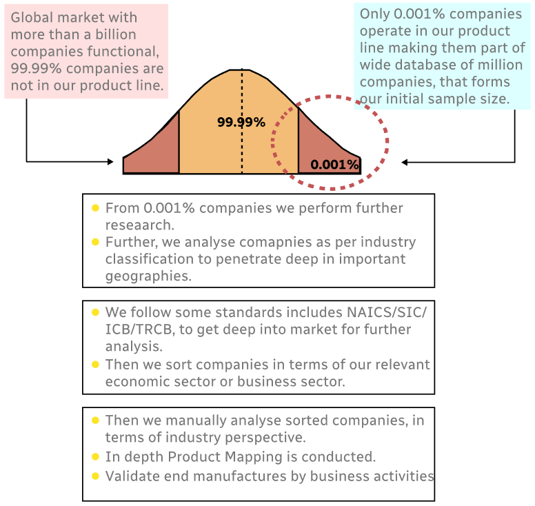
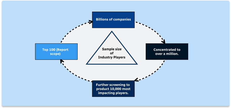
Methodology
Step 1 - Identification of Relevant Samples Size from Population Database
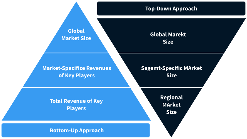
Step 2 - Approaches for Defining Global Market Size (Value, Volume* & Price*)
Note*: In applicable scenarios
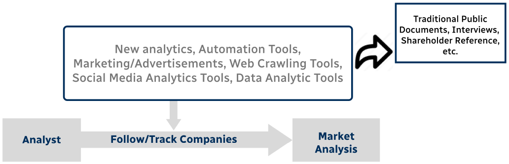
Step 3 - Data Sources
Primary Research
- Web Analytics
- Survey Reports
- Research Institute
- Latest Research Reports
- Opinion Leaders
Secondary Research
- Annual Reports
- White Paper
- Latest Press Release
- Industry Association
- Paid Database
- Investor Presentations
Step 4 - Data Triangulation
Involves using different sources of information in order to increase the validity of a study
These sources are likely to be stakeholders in a program - participants, other researchers, program staff, other community members, and so on.
Then we put all data in single framework & apply various statistical tools to find out the dynamic on the market.
During the analysis stage, feedback from the stakeholder groups would be compared to determine areas of agreement as well as areas of divergence