

Key Insights
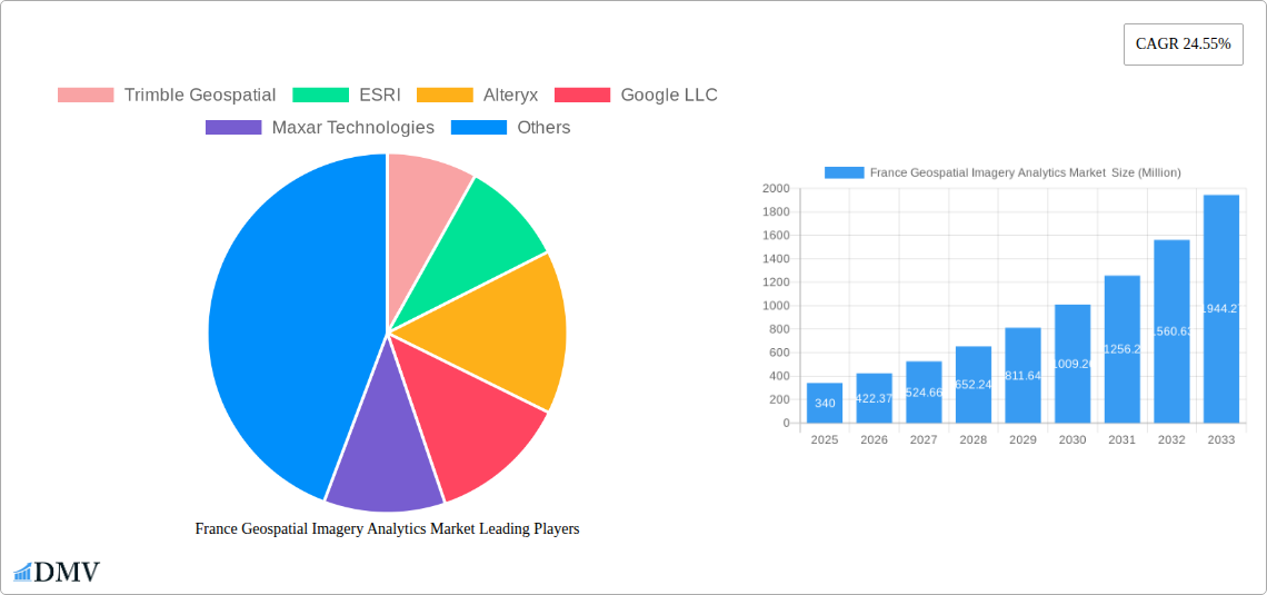
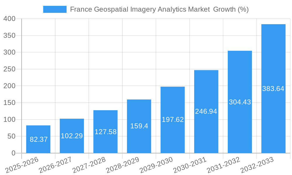
The France Geospatial Imagery Analytics market, valued at €340 million in 2025, is experiencing robust growth, projected to expand at a Compound Annual Growth Rate (CAGR) of 24.55% from 2025 to 2033. This significant expansion is fueled by several key drivers. Firstly, increasing government initiatives focused on infrastructure development and smart city projects are creating a high demand for precise geospatial data and analytics. Secondly, the agricultural sector in France is actively adopting precision farming techniques, leveraging geospatial imagery for optimized resource management and yield improvement. Furthermore, the rising adoption of cloud-based solutions is streamlining data processing and accessibility, lowering the barrier to entry for various businesses. The insurance sector benefits from improved risk assessment using aerial imagery, contributing to market growth. Finally, advancements in artificial intelligence (AI) and machine learning (ML) are enhancing the analytical capabilities of geospatial imagery, leading to more insightful and actionable results. The market segmentation reveals a strong presence across various verticals, with insurance, agriculture, and defense and security leading the way. Cloud deployment is gaining traction over on-premise solutions, mirroring broader technological trends. Large enterprises currently dominate the market, but the SME sector's adoption is anticipated to grow significantly over the forecast period.
However, challenges remain. High initial investment costs associated with advanced geospatial technology can be a barrier for smaller organizations. Data security and privacy concerns, particularly regarding sensitive information gathered through aerial surveillance, require careful attention and robust regulatory frameworks. Moreover, the market faces challenges related to the accuracy and reliability of imagery data, necessitating continuous advancements in image processing and validation techniques. Despite these restraints, the overall market outlook for France's Geospatial Imagery Analytics sector is exceptionally positive, driven by technological innovation and increased demand across various key sectors. Companies like Trimble Geospatial, ESRI, and Google LLC are well-positioned to capitalize on this growth trajectory.
France Geospatial Imagery Analytics Market: A Comprehensive Report (2019-2033)
This insightful report provides a detailed analysis of the France Geospatial Imagery Analytics Market, offering a comprehensive overview of its current state, future trajectory, and key players. The study period covers 2019-2033, with 2025 as the base and estimated year, and a forecast period of 2025-2033. The report is invaluable for stakeholders seeking to understand market dynamics, identify growth opportunities, and make informed strategic decisions. The market is projected to reach xx Million by 2033.
France Geospatial Imagery Analytics Market Market Composition & Trends
The France Geospatial Imagery Analytics market is experiencing significant growth, driven by increasing adoption across diverse verticals. Market concentration is relatively high, with key players like Trimble Geospatial, ESRI, and Maxar Technologies holding substantial market share. However, the emergence of innovative solutions from smaller companies is fostering competition. Regulatory landscapes, particularly concerning data privacy and security, are evolving and influencing market dynamics. Substitute products, such as traditional surveying methods, are gradually being replaced by the efficiency and accuracy of geospatial imagery analytics. End-user profiles span various sectors, including Government, Defense & Security, and Agriculture, each with unique needs and adoption rates. M&A activity within the sector is moderate, with deal values averaging xx Million in recent years.
- Market Share Distribution (2025): Trimble Geospatial (xx%), ESRI (xx%), Maxar Technologies (xx%), Others (xx%).
- M&A Deal Value (2019-2024): Average xx Million per deal.
- Key Innovation Catalysts: Advancements in AI, machine learning, and high-resolution imagery.
- Regulatory Landscape: Compliance with GDPR and other data privacy regulations is crucial.
France Geospatial Imagery Analytics Market Industry Evolution
The France Geospatial Imagery Analytics market has witnessed robust growth over the historical period (2019-2024), with a Compound Annual Growth Rate (CAGR) of xx%. This growth is primarily attributed to technological advancements in sensor technology, improved data processing capabilities, and the increasing affordability of geospatial imagery and analytics solutions. The market is evolving from primarily on-premise deployments towards cloud-based solutions, driven by scalability and cost-effectiveness. Consumer demands are shifting towards more sophisticated analytics, real-time data processing, and integration with other business intelligence tools. The adoption rate of geospatial imagery analytics across various sectors is increasing steadily, particularly in sectors like Agriculture and Environmental Monitoring. Increased government investments in infrastructure projects are also driving the demand for precise spatial data and analytical solutions. The market is expected to maintain a healthy growth trajectory during the forecast period (2025-2033), with a projected CAGR of xx%.
Leading Regions, Countries, or Segments in France Geospatial Imagery Analytics Market
Within the France Geospatial Imagery Analytics market, the Defense and Security sector holds a dominant position, driven by significant government investment in national security initiatives. The Île-de-France region showcases the highest adoption rate due to its concentration of government agencies and private sector players. Cloud-based deployment models are gaining traction, outpacing on-premise solutions due to their flexibility and scalability. Large enterprises are the primary adopters, but SME adoption is growing steadily.
- Key Drivers for Defense & Security: High government expenditure on defense modernization, stringent security requirements.
- Key Drivers for Cloud Deployment: Cost efficiency, scalability, ease of access.
- Key Drivers for Large Enterprises: Data-driven decision making, need for sophisticated analytics capabilities.
- Dominance Factors: Government initiatives, high private sector investment, advanced technological infrastructure.
France Geospatial Imagery Analytics Market Product Innovations
Recent innovations in the France Geospatial Imagery Analytics market include the integration of AI and machine learning for automated feature extraction and analysis, resulting in enhanced accuracy and efficiency. New platforms offer advanced 3D modeling capabilities and improved visualization tools. The development of specialized solutions catering to specific industry needs, such as precision agriculture and infrastructure monitoring, is gaining significant traction. These advancements offer unique selling propositions such as real-time analysis, enhanced data accuracy, and reduced operational costs.
Propelling Factors for France Geospatial Imagery Analytics Market Growth
The France Geospatial Imagery Analytics market growth is fueled by several factors. Technological advancements, such as improved sensor technology and faster processing speeds, are reducing costs and enhancing accuracy. The increasing availability of high-resolution imagery, coupled with decreasing storage costs, are widening accessibility. Government initiatives promoting the use of geospatial data for infrastructure development and environmental monitoring are also providing a significant boost. Furthermore, the growing need for precise location intelligence across sectors like logistics and urban planning is further propelling market expansion.
Obstacles in the France Geospatial Imagery Analytics Market Market
Despite the promising growth prospects, the France Geospatial Imagery Analytics market faces certain challenges. Data privacy regulations and security concerns can hinder data sharing and limit the development of certain applications. The high initial investment cost of advanced geospatial analytics platforms can deter some SMEs from adoption. Competition from established players can also create significant pricing pressures. Supply chain disruptions related to specialized hardware and software components can impact project timelines and budgets.
Future Opportunities in France Geospatial Imagery Analytics Market
The France Geospatial Imagery Analytics market presents considerable future opportunities. The burgeoning Internet of Things (IoT) sector will generate massive amounts of location-based data, fueling demand for advanced analytics. Expansion into new applications like autonomous vehicles and smart city development will further drive market growth. The development of more user-friendly and intuitive software tools will expand the market to a wider range of users. Increased collaboration between technology providers and end-users will foster innovation and customized solutions.
Major Players in the France Geospatial Imagery Analytics Market Ecosystem
- Trimble Geospatial
- ESRI
- Alteryx
- Google LLC
- Maxar Technologies
- Hexagon AB
- Microsoft Corporation
- Oracle Corporation
- L3 Harris Corporation
- Orbital Insights
Key Developments in France Geospatial Imagery Analytics Market Industry
- Jan 2023: ESRI releases a new platform with enhanced AI capabilities.
- May 2022: Maxar Technologies announces a strategic partnership with a French government agency.
- Oct 2021: Trimble Geospatial acquires a smaller French geospatial analytics firm.
- Further details will be included in the full report.
Strategic France Geospatial Imagery Analytics Market Market Forecast
The France Geospatial Imagery Analytics market is poised for sustained growth, driven by technological advancements, increased government investment, and expanding applications across multiple sectors. The market is expected to witness significant expansion in the forecast period, driven by the rising adoption of cloud-based solutions and the integration of AI and machine learning. Emerging opportunities in smart cities, precision agriculture, and autonomous vehicles will further contribute to the market's positive trajectory. The overall market potential is substantial, offering lucrative prospects for both established players and new entrants.
France Geospatial Imagery Analytics Market Segmentation
-
1. Type
- 1.1. Imagery Analytics
- 1.2. Video Analytics
-
2. Deployment Mode
- 2.1. On Premise
- 2.2. Cloud
-
3. Organization Size
- 3.1. SMEs
- 3.2. Large Enterprises
-
4. Vericals
- 4.1. Insurance
- 4.2. Agriculture
- 4.3. Defense and Security
- 4.4. Environmental Monitoring
- 4.5. Engineeting & Construction
- 4.6. Government
- 4.7. Others
France Geospatial Imagery Analytics Market Segmentation By Geography
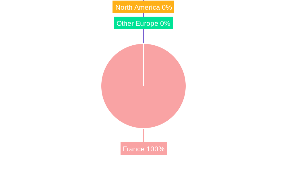
- 1. France
France Geospatial Imagery Analytics Market REPORT HIGHLIGHTS
| Aspects | Details |
|---|---|
| Study Period | 2019-2033 |
| Base Year | 2024 |
| Estimated Year | 2025 |
| Forecast Period | 2025-2033 |
| Historical Period | 2019-2024 |
| Growth Rate | CAGR of 24.55% from 2019-2033 |
| Segmentation |
|
Table of Contents
- 1. Introduction
- 1.1. Research Scope
- 1.2. Market Segmentation
- 1.3. Research Methodology
- 1.4. Definitions and Assumptions
- 2. Executive Summary
- 2.1. Introduction
- 3. Market Dynamics
- 3.1. Introduction
- 3.2. Market Drivers
- 3.2.1. Increasing Adoption of Location-based Services; Increasing Demand for Safe and Secure Mining Operations
- 3.3. Market Restrains
- 3.3.1. Legal and Regulatory Hurdles
- 3.4. Market Trends
- 3.4.1. Cloud Segment is Expected to Hold a Significant Share of the Market
- 4. Market Factor Analysis
- 4.1. Porters Five Forces
- 4.2. Supply/Value Chain
- 4.3. PESTEL analysis
- 4.4. Market Entropy
- 4.5. Patent/Trademark Analysis
- 5. France Geospatial Imagery Analytics Market Analysis, Insights and Forecast, 2019-2031
- 5.1. Market Analysis, Insights and Forecast - by Type
- 5.1.1. Imagery Analytics
- 5.1.2. Video Analytics
- 5.2. Market Analysis, Insights and Forecast - by Deployment Mode
- 5.2.1. On Premise
- 5.2.2. Cloud
- 5.3. Market Analysis, Insights and Forecast - by Organization Size
- 5.3.1. SMEs
- 5.3.2. Large Enterprises
- 5.4. Market Analysis, Insights and Forecast - by Vericals
- 5.4.1. Insurance
- 5.4.2. Agriculture
- 5.4.3. Defense and Security
- 5.4.4. Environmental Monitoring
- 5.4.5. Engineeting & Construction
- 5.4.6. Government
- 5.4.7. Others
- 5.5. Market Analysis, Insights and Forecast - by Region
- 5.5.1. France
- 5.1. Market Analysis, Insights and Forecast - by Type
- 6. Competitive Analysis
- 6.1. Market Share Analysis 2024
- 6.2. Company Profiles
- 6.2.1 Trimble Geospatial
- 6.2.1.1. Overview
- 6.2.1.2. Products
- 6.2.1.3. SWOT Analysis
- 6.2.1.4. Recent Developments
- 6.2.1.5. Financials (Based on Availability)
- 6.2.2 ESRI
- 6.2.2.1. Overview
- 6.2.2.2. Products
- 6.2.2.3. SWOT Analysis
- 6.2.2.4. Recent Developments
- 6.2.2.5. Financials (Based on Availability)
- 6.2.3 Alteryx
- 6.2.3.1. Overview
- 6.2.3.2. Products
- 6.2.3.3. SWOT Analysis
- 6.2.3.4. Recent Developments
- 6.2.3.5. Financials (Based on Availability)
- 6.2.4 Google LLC
- 6.2.4.1. Overview
- 6.2.4.2. Products
- 6.2.4.3. SWOT Analysis
- 6.2.4.4. Recent Developments
- 6.2.4.5. Financials (Based on Availability)
- 6.2.5 Maxar Technologies
- 6.2.5.1. Overview
- 6.2.5.2. Products
- 6.2.5.3. SWOT Analysis
- 6.2.5.4. Recent Developments
- 6.2.5.5. Financials (Based on Availability)
- 6.2.6 Hexagon AB
- 6.2.6.1. Overview
- 6.2.6.2. Products
- 6.2.6.3. SWOT Analysis
- 6.2.6.4. Recent Developments
- 6.2.6.5. Financials (Based on Availability)
- 6.2.7 Microsoft Corporation
- 6.2.7.1. Overview
- 6.2.7.2. Products
- 6.2.7.3. SWOT Analysis
- 6.2.7.4. Recent Developments
- 6.2.7.5. Financials (Based on Availability)
- 6.2.8 Oracle Corporation
- 6.2.8.1. Overview
- 6.2.8.2. Products
- 6.2.8.3. SWOT Analysis
- 6.2.8.4. Recent Developments
- 6.2.8.5. Financials (Based on Availability)
- 6.2.9 L3 Harris Corporation
- 6.2.9.1. Overview
- 6.2.9.2. Products
- 6.2.9.3. SWOT Analysis
- 6.2.9.4. Recent Developments
- 6.2.9.5. Financials (Based on Availability)
- 6.2.10 Orbital Insights
- 6.2.10.1. Overview
- 6.2.10.2. Products
- 6.2.10.3. SWOT Analysis
- 6.2.10.4. Recent Developments
- 6.2.10.5. Financials (Based on Availability)
- 6.2.1 Trimble Geospatial
List of Figures
- Figure 1: France Geospatial Imagery Analytics Market Revenue Breakdown (Million, %) by Product 2024 & 2032
- Figure 2: France Geospatial Imagery Analytics Market Share (%) by Company 2024
List of Tables
- Table 1: France Geospatial Imagery Analytics Market Revenue Million Forecast, by Region 2019 & 2032
- Table 2: France Geospatial Imagery Analytics Market Volume K Unit Forecast, by Region 2019 & 2032
- Table 3: France Geospatial Imagery Analytics Market Revenue Million Forecast, by Type 2019 & 2032
- Table 4: France Geospatial Imagery Analytics Market Volume K Unit Forecast, by Type 2019 & 2032
- Table 5: France Geospatial Imagery Analytics Market Revenue Million Forecast, by Deployment Mode 2019 & 2032
- Table 6: France Geospatial Imagery Analytics Market Volume K Unit Forecast, by Deployment Mode 2019 & 2032
- Table 7: France Geospatial Imagery Analytics Market Revenue Million Forecast, by Organization Size 2019 & 2032
- Table 8: France Geospatial Imagery Analytics Market Volume K Unit Forecast, by Organization Size 2019 & 2032
- Table 9: France Geospatial Imagery Analytics Market Revenue Million Forecast, by Vericals 2019 & 2032
- Table 10: France Geospatial Imagery Analytics Market Volume K Unit Forecast, by Vericals 2019 & 2032
- Table 11: France Geospatial Imagery Analytics Market Revenue Million Forecast, by Region 2019 & 2032
- Table 12: France Geospatial Imagery Analytics Market Volume K Unit Forecast, by Region 2019 & 2032
- Table 13: France Geospatial Imagery Analytics Market Revenue Million Forecast, by Country 2019 & 2032
- Table 14: France Geospatial Imagery Analytics Market Volume K Unit Forecast, by Country 2019 & 2032
- Table 15: France Geospatial Imagery Analytics Market Revenue Million Forecast, by Type 2019 & 2032
- Table 16: France Geospatial Imagery Analytics Market Volume K Unit Forecast, by Type 2019 & 2032
- Table 17: France Geospatial Imagery Analytics Market Revenue Million Forecast, by Deployment Mode 2019 & 2032
- Table 18: France Geospatial Imagery Analytics Market Volume K Unit Forecast, by Deployment Mode 2019 & 2032
- Table 19: France Geospatial Imagery Analytics Market Revenue Million Forecast, by Organization Size 2019 & 2032
- Table 20: France Geospatial Imagery Analytics Market Volume K Unit Forecast, by Organization Size 2019 & 2032
- Table 21: France Geospatial Imagery Analytics Market Revenue Million Forecast, by Vericals 2019 & 2032
- Table 22: France Geospatial Imagery Analytics Market Volume K Unit Forecast, by Vericals 2019 & 2032
- Table 23: France Geospatial Imagery Analytics Market Revenue Million Forecast, by Country 2019 & 2032
- Table 24: France Geospatial Imagery Analytics Market Volume K Unit Forecast, by Country 2019 & 2032
Frequently Asked Questions
1. What is the projected Compound Annual Growth Rate (CAGR) of the France Geospatial Imagery Analytics Market ?
The projected CAGR is approximately 24.55%.
2. Which companies are prominent players in the France Geospatial Imagery Analytics Market ?
Key companies in the market include Trimble Geospatial, ESRI, Alteryx, Google LLC, Maxar Technologies, Hexagon AB, Microsoft Corporation, Oracle Corporation, L3 Harris Corporation, Orbital Insights.
3. What are the main segments of the France Geospatial Imagery Analytics Market ?
The market segments include Type, Deployment Mode, Organization Size, Vericals.
4. Can you provide details about the market size?
The market size is estimated to be USD 0.34 Million as of 2022.
5. What are some drivers contributing to market growth?
Increasing Adoption of Location-based Services; Increasing Demand for Safe and Secure Mining Operations.
6. What are the notable trends driving market growth?
Cloud Segment is Expected to Hold a Significant Share of the Market.
7. Are there any restraints impacting market growth?
Legal and Regulatory Hurdles.
8. Can you provide examples of recent developments in the market?
N/A
9. What pricing options are available for accessing the report?
Pricing options include single-user, multi-user, and enterprise licenses priced at USD 3800, USD 4500, and USD 5800 respectively.
10. Is the market size provided in terms of value or volume?
The market size is provided in terms of value, measured in Million and volume, measured in K Unit.
11. Are there any specific market keywords associated with the report?
Yes, the market keyword associated with the report is "France Geospatial Imagery Analytics Market ," which aids in identifying and referencing the specific market segment covered.
12. How do I determine which pricing option suits my needs best?
The pricing options vary based on user requirements and access needs. Individual users may opt for single-user licenses, while businesses requiring broader access may choose multi-user or enterprise licenses for cost-effective access to the report.
13. Are there any additional resources or data provided in the France Geospatial Imagery Analytics Market report?
While the report offers comprehensive insights, it's advisable to review the specific contents or supplementary materials provided to ascertain if additional resources or data are available.
14. How can I stay updated on further developments or reports in the France Geospatial Imagery Analytics Market ?
To stay informed about further developments, trends, and reports in the France Geospatial Imagery Analytics Market , consider subscribing to industry newsletters, following relevant companies and organizations, or regularly checking reputable industry news sources and publications.
Methodology
Step 1 - Identification of Relevant Samples Size from Population Database


Step 2 - Approaches for Defining Global Market Size (Value, Volume* & Price*)

Note*: In applicable scenarios
Step 3 - Data Sources
Primary Research
- Web Analytics
- Survey Reports
- Research Institute
- Latest Research Reports
- Opinion Leaders
Secondary Research
- Annual Reports
- White Paper
- Latest Press Release
- Industry Association
- Paid Database
- Investor Presentations

Step 4 - Data Triangulation
Involves using different sources of information in order to increase the validity of a study
These sources are likely to be stakeholders in a program - participants, other researchers, program staff, other community members, and so on.
Then we put all data in single framework & apply various statistical tools to find out the dynamic on the market.
During the analysis stage, feedback from the stakeholder groups would be compared to determine areas of agreement as well as areas of divergence
