

Key Insights
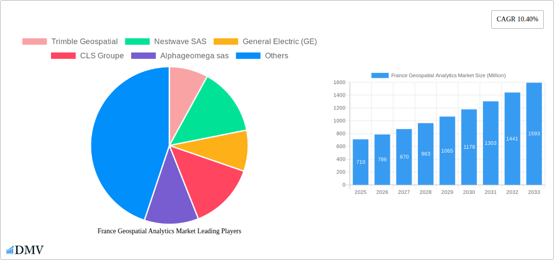
The France geospatial analytics market, valued at €0.71 billion in 2025, is projected to experience robust growth, driven by increasing adoption across diverse sectors. A Compound Annual Growth Rate (CAGR) of 10.40% from 2025 to 2033 indicates a significant expansion of the market over the forecast period. Key drivers include the rising need for precise location intelligence in agriculture for optimized yield and resource management, the expanding utilization of geospatial data for efficient network planning and management in utilities and communication, and growing demand for advanced analytics in defense and intelligence applications. Furthermore, the market is fueled by advancements in geospatial technologies, including improved satellite imagery, sensor data, and sophisticated analytical tools capable of processing and interpreting vast datasets. Government initiatives promoting digital transformation and smart city development also contribute significantly to market expansion. Market segmentation reveals strong growth across various end-user verticals like agriculture, utilities, and defense, along with continued demand for both surface and network analysis, coupled with rising adoption of geovisualization tools. Competition is relatively high, with key players such as Trimble Geospatial, ESRI Inc, and Bentley Systems Inc, amongst others, striving to offer innovative solutions and cater to diverse customer needs.
The robust growth trajectory of the French geospatial analytics market is supported by several factors, including increasing government investment in infrastructure projects leveraging geospatial data, the rise of precision farming techniques, and the growing adoption of cloud-based geospatial analytics platforms. These factors are expected to drive increased demand for sophisticated geospatial analytics solutions throughout the forecast period, leading to substantial market expansion. The market's segmentation by type (surface analysis, network analysis, geovisualization) suggests opportunities for specialized providers catering to specific analytic needs. While challenges such as data security concerns and the need for skilled professionals exist, the overall market outlook remains positive, with significant growth potential in the coming years within France, potentially influencing neighboring European markets.
France Geospatial Analytics Market: A Comprehensive Report (2019-2033)
This insightful report delivers a comprehensive analysis of the France Geospatial Analytics Market, providing a detailed overview of market trends, key players, growth drivers, and future opportunities. The study period spans from 2019 to 2033, with 2025 serving as the base and estimated year. The report projects a market value of xx Million by 2033, fueled by significant technological advancements and increasing government investments. This in-depth analysis is crucial for stakeholders seeking to understand the dynamics of this rapidly evolving market and make informed strategic decisions.
France Geospatial Analytics Market Market Composition & Trends
The France Geospatial Analytics Market exhibits a moderately concentrated landscape, with several major players and a growing number of niche players competing for market share. Market share distribution in 2025 is estimated as follows: Trimble Geospatial (15%), ESRI Inc. (12%), Bentley Systems Inc. (10%), and other players accounting for the remaining 63%. Innovation is a key catalyst, driven by advancements in AI, machine learning, and cloud-based solutions. The regulatory landscape is characterized by evolving data privacy regulations (e.g., GDPR compliance) and increasing emphasis on data security. Substitute products such as traditional surveying methods are gradually losing ground to the efficiency and precision of geospatial analytics.
End-user profiles vary widely, from government agencies leveraging geospatial data for urban planning to agricultural businesses employing precision farming techniques. M&A activity has been moderate in recent years, with deal values averaging xx Million per transaction. Key M&A activities include (limited information available – details require further research):
- Consolidation among smaller firms to enhance technological capabilities.
- Acquisitions by larger players to expand market reach and product portfolios.
France Geospatial Analytics Market Industry Evolution
The France Geospatial Analytics Market has witnessed robust growth from 2019 to 2024, experiencing a Compound Annual Growth Rate (CAGR) of xx%. This growth trajectory is projected to continue throughout the forecast period (2025-2033), driven by increasing adoption of geospatial technologies across various sectors. The advancements in technologies such as AI, machine learning, and cloud computing have improved the accuracy, speed, and efficiency of geospatial analytics. The integration of IoT devices and the collection of real-time data, coupled with high-resolution imagery, have broadened the applications of this technology. Furthermore, shifting consumer demands, particularly within the private sector, towards data-driven decision-making have fueled market expansion. Adoption metrics suggest a significant increase in the utilization of geospatial analytics solutions by both public and private entities. Specific growth rates for various segments and end-user verticals are detailed in the full report.
Leading Regions, Countries, or Segments in France Geospatial Analytics Market
The dominance in the French geospatial analytics market is shared across several segments and driven by varied factors:
By End-user Vertical:
- Government: High government spending on infrastructure projects and smart city initiatives is a primary driver. Strong regulatory support for geospatial data utilization further contributes.
- Real Estate and Construction: The demand for precise land surveying, urban planning, and facility management is significantly increasing market share in this sector.
- Defense and Intelligence: The use of geospatial intelligence for strategic decision-making and national security is a key driver.
By Type:
- Geovisualization: The demand for interactive data visualization tools and intuitive platforms is fueling growth within this segment.
- Surface Analysis: Increasing requirements for precise terrain modeling and surface feature extraction in various sectors are leading to strong growth.
The Île-de-France region is expected to lead the market due to the concentration of businesses and the availability of high-quality geospatial data infrastructure.
France Geospatial Analytics Market Product Innovations
Recent innovations include advanced analytics platforms incorporating AI and machine learning to enhance accuracy and automate processes. Cloud-based solutions offering scalability and cost-effectiveness are gaining popularity. Unique selling propositions focus on user-friendly interfaces, seamless data integration, and specialized analytical capabilities tailored for specific industries. The integration of LiDAR and other high-resolution sensor technologies has been crucial in improving data accuracy and resolution for creating 3D models.
Propelling Factors for France Geospatial Analytics Market Growth
Technological advancements (AI, IoT, cloud computing), increasing government investments in infrastructure and smart city initiatives, and growing demand for data-driven decision-making across various sectors (agriculture, utilities, defense) are key growth drivers. The implementation of robust data privacy regulations helps build trust and stimulates wider adoption.
Obstacles in the France Geospatial Analytics Market Market
Data security concerns, the complexity of integrating disparate data sources, and the high initial investment costs for certain solutions can impede market growth. Limited skilled workforce availability presents another challenge to market expansion. Competition from established players and emerging startups is intense and influences market dynamics.
Future Opportunities in France Geospatial Analytics Market
Emerging opportunities include the expansion of 5G network capabilities enabling real-time data transmission for applications such as autonomous vehicles and smart agriculture, and the integration of geospatial analytics with other technologies (e.g., blockchain). The adoption of geospatial analytics in the healthcare and renewable energy sectors provides significant potential for future expansion.
Major Players in the France Geospatial Analytics Market Ecosystem
- Trimble Geospatial
- Nestwave SAS
- General Electric (GE)
- CLS Groupe
- Alphageomega sas
- ESRI Inc
- Harris Corporation
- Geomatys
- Bentley Systems Inc
- Intermap Technologies
Key Developments in France Geospatial Analytics Market Industry
- July 2023: GeoCue partners with Escadrone, expanding its presence in the French market with advanced TrueView 3D Imaging Sensors and LP360 LiDAR Processing Software. This enhances surveying and mapping capabilities for French customers.
- January 2023: The AFD and Rwandan Government collaborate on a geospatial hub, boosting Rwanda’s drone sector and indirectly influencing the European geospatial market.
Strategic France Geospatial Analytics Market Market Forecast
The France Geospatial Analytics Market is poised for significant growth, driven by continuous technological innovations, increasing data availability, and expanding applications across diverse industries. The market’s future potential is considerable, offering substantial opportunities for both established players and new entrants. The projected CAGR during the forecast period indicates a healthy and robust expansion of the market, presenting lucrative prospects for investors and businesses operating within this sector.
France Geospatial Analytics Market Segmentation
-
1. Type
- 1.1. Surface Analysis
- 1.2. Network Analysis
- 1.3. Geovisualization
-
2. End-user Vertical
- 2.1. Agriculture
- 2.2. Utility and Communication
- 2.3. Defense and Intelligence
- 2.4. Government
- 2.5. Mining and Natural Resources
- 2.6. Automotive and Transportation
- 2.7. Healthcare
- 2.8. Real Estate and Construction
- 2.9. Other End-user Verticals
France Geospatial Analytics Market Segmentation By Geography
- 1. France
France Geospatial Analytics Market REPORT HIGHLIGHTS
| Aspects | Details |
|---|---|
| Study Period | 2019-2033 |
| Base Year | 2024 |
| Estimated Year | 2025 |
| Forecast Period | 2025-2033 |
| Historical Period | 2019-2024 |
| Growth Rate | CAGR of 10.40% from 2019-2033 |
| Segmentation |
|
Table of Contents
- 1. Introduction
- 1.1. Research Scope
- 1.2. Market Segmentation
- 1.3. Research Methodology
- 1.4. Definitions and Assumptions
- 2. Executive Summary
- 2.1. Introduction
- 3. Market Dynamics
- 3.1. Introduction
- 3.2. Market Drivers
- 3.2.1. Advancement in Technology; Rising Awareness of Location Based Service
- 3.3. Market Restrains
- 3.3.1. High Initial Cost in Implementing Geospatial Analytics Solutions
- 3.4. Market Trends
- 3.4.1. Increasing Adoption of 5G in France is Boosting the Market Growth
- 4. Market Factor Analysis
- 4.1. Porters Five Forces
- 4.2. Supply/Value Chain
- 4.3. PESTEL analysis
- 4.4. Market Entropy
- 4.5. Patent/Trademark Analysis
- 5. France Geospatial Analytics Market Analysis, Insights and Forecast, 2019-2031
- 5.1. Market Analysis, Insights and Forecast - by Type
- 5.1.1. Surface Analysis
- 5.1.2. Network Analysis
- 5.1.3. Geovisualization
- 5.2. Market Analysis, Insights and Forecast - by End-user Vertical
- 5.2.1. Agriculture
- 5.2.2. Utility and Communication
- 5.2.3. Defense and Intelligence
- 5.2.4. Government
- 5.2.5. Mining and Natural Resources
- 5.2.6. Automotive and Transportation
- 5.2.7. Healthcare
- 5.2.8. Real Estate and Construction
- 5.2.9. Other End-user Verticals
- 5.3. Market Analysis, Insights and Forecast - by Region
- 5.3.1. France
- 5.1. Market Analysis, Insights and Forecast - by Type
- 6. Competitive Analysis
- 6.1. Market Share Analysis 2024
- 6.2. Company Profiles
- 6.2.1 Trimble Geospatial
- 6.2.1.1. Overview
- 6.2.1.2. Products
- 6.2.1.3. SWOT Analysis
- 6.2.1.4. Recent Developments
- 6.2.1.5. Financials (Based on Availability)
- 6.2.2 Nestwave SAS
- 6.2.2.1. Overview
- 6.2.2.2. Products
- 6.2.2.3. SWOT Analysis
- 6.2.2.4. Recent Developments
- 6.2.2.5. Financials (Based on Availability)
- 6.2.3 General Electric (GE)
- 6.2.3.1. Overview
- 6.2.3.2. Products
- 6.2.3.3. SWOT Analysis
- 6.2.3.4. Recent Developments
- 6.2.3.5. Financials (Based on Availability)
- 6.2.4 CLS Groupe
- 6.2.4.1. Overview
- 6.2.4.2. Products
- 6.2.4.3. SWOT Analysis
- 6.2.4.4. Recent Developments
- 6.2.4.5. Financials (Based on Availability)
- 6.2.5 Alphageomega sas
- 6.2.5.1. Overview
- 6.2.5.2. Products
- 6.2.5.3. SWOT Analysis
- 6.2.5.4. Recent Developments
- 6.2.5.5. Financials (Based on Availability)
- 6.2.6 ESRI Inc
- 6.2.6.1. Overview
- 6.2.6.2. Products
- 6.2.6.3. SWOT Analysis
- 6.2.6.4. Recent Developments
- 6.2.6.5. Financials (Based on Availability)
- 6.2.7 Harris Corporation
- 6.2.7.1. Overview
- 6.2.7.2. Products
- 6.2.7.3. SWOT Analysis
- 6.2.7.4. Recent Developments
- 6.2.7.5. Financials (Based on Availability)
- 6.2.8 Geomatys
- 6.2.8.1. Overview
- 6.2.8.2. Products
- 6.2.8.3. SWOT Analysis
- 6.2.8.4. Recent Developments
- 6.2.8.5. Financials (Based on Availability)
- 6.2.9 Bentley Systems Inc
- 6.2.9.1. Overview
- 6.2.9.2. Products
- 6.2.9.3. SWOT Analysis
- 6.2.9.4. Recent Developments
- 6.2.9.5. Financials (Based on Availability)
- 6.2.10 Intermap Technologies
- 6.2.10.1. Overview
- 6.2.10.2. Products
- 6.2.10.3. SWOT Analysis
- 6.2.10.4. Recent Developments
- 6.2.10.5. Financials (Based on Availability)
- 6.2.1 Trimble Geospatial
List of Figures
- Figure 1: France Geospatial Analytics Market Revenue Breakdown (Million, %) by Product 2024 & 2032
- Figure 2: France Geospatial Analytics Market Share (%) by Company 2024
List of Tables
- Table 1: France Geospatial Analytics Market Revenue Million Forecast, by Region 2019 & 2032
- Table 2: France Geospatial Analytics Market Revenue Million Forecast, by Type 2019 & 2032
- Table 3: France Geospatial Analytics Market Revenue Million Forecast, by End-user Vertical 2019 & 2032
- Table 4: France Geospatial Analytics Market Revenue Million Forecast, by Region 2019 & 2032
- Table 5: France Geospatial Analytics Market Revenue Million Forecast, by Country 2019 & 2032
- Table 6: France Geospatial Analytics Market Revenue Million Forecast, by Type 2019 & 2032
- Table 7: France Geospatial Analytics Market Revenue Million Forecast, by End-user Vertical 2019 & 2032
- Table 8: France Geospatial Analytics Market Revenue Million Forecast, by Country 2019 & 2032
Frequently Asked Questions
1. What is the projected Compound Annual Growth Rate (CAGR) of the France Geospatial Analytics Market?
The projected CAGR is approximately 10.40%.
2. Which companies are prominent players in the France Geospatial Analytics Market?
Key companies in the market include Trimble Geospatial, Nestwave SAS, General Electric (GE), CLS Groupe, Alphageomega sas, ESRI Inc, Harris Corporation, Geomatys, Bentley Systems Inc, Intermap Technologies.
3. What are the main segments of the France Geospatial Analytics Market?
The market segments include Type, End-user Vertical.
4. Can you provide details about the market size?
The market size is estimated to be USD 0.71 Million as of 2022.
5. What are some drivers contributing to market growth?
Advancement in Technology; Rising Awareness of Location Based Service.
6. What are the notable trends driving market growth?
Increasing Adoption of 5G in France is Boosting the Market Growth.
7. Are there any restraints impacting market growth?
High Initial Cost in Implementing Geospatial Analytics Solutions.
8. Can you provide examples of recent developments in the market?
July 2023: GeoCue, a leading provider of advanced geospatial software and hardware solutions, has partnered with Escadrone, an expert in autonomous robotics integration. This partnership marks an expansion of GeoCue's presence in the European market, particularly in France, where Escadrone will offer advanced-level TrueView 3D Imaging Sensors and LP360 LiDAR Processing Software. With this partnership, Escadrone will likely provide TrueView Lidar products and LP360 software, empowering its customers to enhance their surveying and mapping capabilities.
9. What pricing options are available for accessing the report?
Pricing options include single-user, multi-user, and enterprise licenses priced at USD 3800, USD 4500, and USD 5800 respectively.
10. Is the market size provided in terms of value or volume?
The market size is provided in terms of value, measured in Million.
11. Are there any specific market keywords associated with the report?
Yes, the market keyword associated with the report is "France Geospatial Analytics Market," which aids in identifying and referencing the specific market segment covered.
12. How do I determine which pricing option suits my needs best?
The pricing options vary based on user requirements and access needs. Individual users may opt for single-user licenses, while businesses requiring broader access may choose multi-user or enterprise licenses for cost-effective access to the report.
13. Are there any additional resources or data provided in the France Geospatial Analytics Market report?
While the report offers comprehensive insights, it's advisable to review the specific contents or supplementary materials provided to ascertain if additional resources or data are available.
14. How can I stay updated on further developments or reports in the France Geospatial Analytics Market?
To stay informed about further developments, trends, and reports in the France Geospatial Analytics Market, consider subscribing to industry newsletters, following relevant companies and organizations, or regularly checking reputable industry news sources and publications.
Methodology
Step 1 - Identification of Relevant Samples Size from Population Database


Step 2 - Approaches for Defining Global Market Size (Value, Volume* & Price*)

Note*: In applicable scenarios
Step 3 - Data Sources
Primary Research
- Web Analytics
- Survey Reports
- Research Institute
- Latest Research Reports
- Opinion Leaders
Secondary Research
- Annual Reports
- White Paper
- Latest Press Release
- Industry Association
- Paid Database
- Investor Presentations

Step 4 - Data Triangulation
Involves using different sources of information in order to increase the validity of a study
These sources are likely to be stakeholders in a program - participants, other researchers, program staff, other community members, and so on.
Then we put all data in single framework & apply various statistical tools to find out the dynamic on the market.
During the analysis stage, feedback from the stakeholder groups would be compared to determine areas of agreement as well as areas of divergence
