

Key Insights
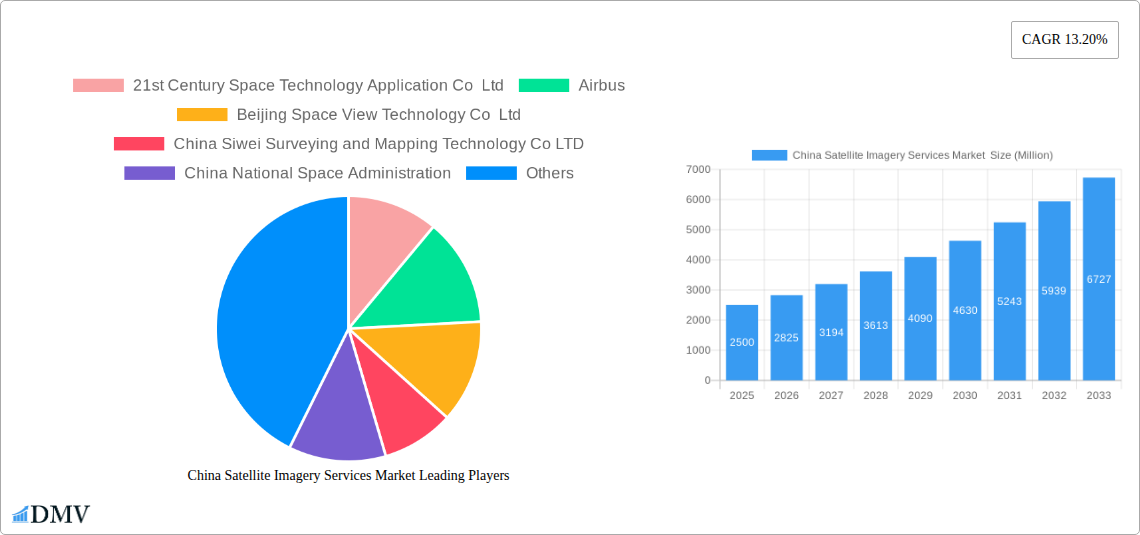
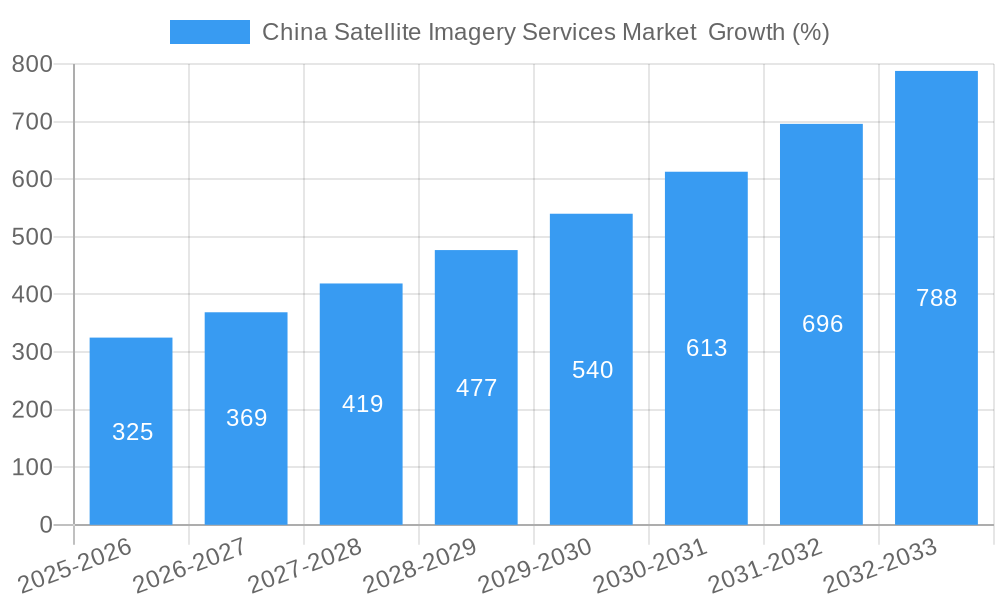
The China satellite imagery services market is experiencing robust growth, fueled by increasing government investment in infrastructure development, stringent environmental monitoring regulations, and a rising need for precise geospatial data across various sectors. The market's Compound Annual Growth Rate (CAGR) of 13.20% from 2019 to 2024 indicates significant expansion, projected to continue over the forecast period (2025-2033). Key application areas driving this growth include geospatial data acquisition and mapping for urban planning and infrastructure projects, natural resource management for efficient land use and environmental protection, and surveillance and security for public safety and border control. The government sector remains a dominant end-user, followed by the construction, transportation, and logistics sectors, all benefiting from the high-resolution and timely data provided by satellite imagery. Furthermore, the increasing adoption of advanced technologies like AI and machine learning for data analysis is enhancing the value proposition of satellite imagery, further stimulating market expansion. Competition is relatively intense, with both domestic and international players vying for market share. Chinese companies like 21st Century Space Technology Application Co Ltd and Beijing Space View Technology Co Ltd are well-positioned to capitalize on the domestic demand, while international firms like Airbus and Mapbox offer specialized services and technologies.
While the market enjoys significant growth drivers, challenges remain. Data security and privacy concerns surrounding the use of satellite imagery necessitate robust regulatory frameworks. Moreover, the high cost of satellite technology and data processing can pose a barrier to entry for smaller companies. Despite these restraints, the overall market outlook remains positive, with ongoing technological advancements and increasing demand for precise location-based intelligence expected to drive sustained growth in the coming years. The market's size in 2025 is estimated to be significant, based on the provided CAGR and considering the substantial investments and government support within the sector. Further expansion is anticipated as the application of satellite imagery expands into new sectors and applications, creating new opportunities for innovation and growth.
China Satellite Imagery Services Market: A Comprehensive Market Report (2019-2033)
This insightful report provides a detailed analysis of the China Satellite Imagery Services Market, offering a comprehensive overview of market dynamics, key players, and future growth prospects. The study period covers 2019-2033, with 2025 serving as the base and estimated year. The forecast period spans 2025-2033, and the historical period encompasses 2019-2024. This report is essential for stakeholders seeking to understand the current landscape and anticipate future trends in this rapidly evolving market, projected to reach xx Million by 2033.
China Satellite Imagery Services Market Composition & Trends
This section meticulously examines the competitive landscape of the China Satellite Imagery Services Market, evaluating market concentration, innovation drivers, regulatory frameworks, substitute products, end-user profiles, and merger & acquisition (M&A) activities. The market exhibits a moderately concentrated structure, with key players such as 21st Century Space Technology Application Co Ltd, Airbus, and Beijing Space View Technology Co Ltd holding significant market share. However, the emergence of smaller, agile companies is increasing competition. The market share distribution is estimated as follows (2025): Top 3 players account for approximately xx%, while the remaining market share is distributed among numerous smaller players. Innovation is driven by advancements in sensor technology, data processing capabilities, and the development of AI-powered analytics. The regulatory landscape is evolving, with increasing emphasis on data privacy and security. The total value of M&A deals in the sector from 2019-2024 was approximately xx Million, reflecting consolidation activity. Substitute products include traditional aerial photography and LiDAR surveys; however, satellite imagery offers superior coverage, efficiency, and cost-effectiveness in many applications. Major end-users are predominantly government bodies, construction, transportation and logistics, military and defense, and forestry sectors.
- Market Concentration: Moderately concentrated, with top 3 players holding xx% market share (2025).
- Innovation Catalysts: Advancements in sensor technology, AI-powered analytics, and data processing.
- Regulatory Landscape: Evolving, with growing focus on data security and privacy.
- Substitute Products: Aerial photography, LiDAR.
- M&A Activity: Total deal value (2019-2024): xx Million.
China Satellite Imagery Services Market Industry Evolution
The China Satellite Imagery Services Market has witnessed significant growth over the past few years, fueled by technological advancements and increasing demand across various sectors. The market experienced a Compound Annual Growth Rate (CAGR) of xx% from 2019 to 2024, and is projected to maintain a CAGR of xx% during the forecast period (2025-2033). This growth is attributed to several factors: the increasing adoption of satellite imagery for various applications such as urban planning, environmental monitoring, and precision agriculture; the development of high-resolution sensors and improved data processing capabilities; the increasing affordability of satellite imagery data; and government initiatives promoting the use of space technology. The market is also seeing a shift towards cloud-based solutions, offering greater accessibility and scalability. Technological advancements such as hyperspectral imaging and synthetic aperture radar (SAR) are transforming the industry, enabling more detailed and comprehensive analyses. Growing demand for real-time data analysis and predictive modeling is further driving innovation and market growth. The increasing demand for high-resolution imagery, driven by applications like urban planning and security, is expected to contribute significantly to the market's future growth.
Leading Regions, Countries, or Segments in China Satellite Imagery Services Market
The Government segment dominates the end-user landscape, driven by increasing government investment in infrastructure development and national security initiatives. Within applications, Geospatial Data Acquisition and Mapping holds the largest market share, owing to its widespread use in urban planning, infrastructure development, and resource management.
Key Drivers (Government Segment):
- Substantial government investments in infrastructure and national security.
- Stringent regulations promoting the use of satellite imagery for mapping and planning.
- Government-led initiatives to enhance national spatial data infrastructure.
Key Drivers (Geospatial Data Acquisition and Mapping):
- Increasing demand for accurate and up-to-date geospatial data.
- Rising urbanization and infrastructure development projects.
- Growing adoption of GIS and spatial analytics technologies.
The coastal regions of China, including Guangdong, Jiangsu, and Zhejiang, exhibit higher growth rates due to greater economic activity and higher adoption rates of advanced technologies. The dominance of these segments is anticipated to continue throughout the forecast period, owing to sustained demand and ongoing technological advancements.
China Satellite Imagery Services Market Product Innovations
Recent advancements in satellite imagery technology include higher resolution sensors, enabling detailed image capture, and improved processing capabilities that enhance data extraction efficiency. New applications, such as precision agriculture leveraging hyperspectral imaging, are emerging, providing unique selling propositions like crop health monitoring and yield prediction. The development of AI-powered analytics tools further enhances data utility, facilitating automated feature extraction and anomaly detection.
Propelling Factors for China Satellite Imagery Services Market Growth
Technological advancements, such as the development of high-resolution sensors and advanced analytics, are major drivers of market growth. Government initiatives promoting space technology and the adoption of satellite imagery across various sectors are also fueling market expansion. The increasing availability of affordable satellite imagery data further contributes to its widespread adoption. For instance, the recent sharing of satellite imagery data with BRICS nations demonstrates the expanding market opportunities.
Obstacles in the China Satellite Imagery Services Market
Regulatory hurdles related to data privacy and security pose challenges for market participants. Supply chain disruptions impacting sensor manufacturing and data processing capabilities can also impact market growth. Intense competition from both established players and emerging entrants creates pricing pressures. The dependence on foreign technology for certain components presents a risk, impacting the market's overall resilience.
Future Opportunities in China Satellite Imagery Services Market
Emerging opportunities include the expansion into new applications, such as environmental monitoring and disaster management, and the development of innovative products and services leveraging advanced technologies like AI and machine learning. The growing demand for real-time data analysis and predictive modeling also presents significant opportunities for market players. The development of new constellations of satellites offering improved coverage and data frequency offers immense potential.
Major Players in the China Satellite Imagery Services Market Ecosystem
- 21st Century Space Technology Application Co Ltd
- Airbus (Airbus)
- Beijing Space View Technology Co Ltd
- China Siwei Surveying and Mapping Technology Co LTD
- China National Space Administration
- Mapbox (Mapbox)
- Beijing Zero Map Information Technology Co Ltd
- CHANG GUANG SATELLITE TECHNOLOGY CO LTD
- National Satellite Meteorological Center
- HEAD Aerospace Group
Key Developments in China Satellite Imagery Services Market Industry
- June 2023: China shared 400 scenes (1.5 TB) of satellite imagery data with BRICS nations, creating significant market opportunities for Chinese vendors. This initiative underscores the increasing international collaboration and data sharing in the sector.
- January 2023: Spacety supplied SAR satellite images to a Russian firm, highlighting the role of Chinese companies in military applications and contributing to market growth.
Strategic China Satellite Imagery Services Market Forecast
The China Satellite Imagery Services Market is poised for sustained growth, driven by technological innovation, government support, and expanding application across diverse sectors. The continued development of high-resolution sensors, advanced analytics, and cloud-based solutions will shape future market dynamics. The increasing adoption of satellite imagery for crucial national initiatives and international collaborations points towards substantial market expansion throughout the forecast period, with the potential to significantly exceed projected values.
China Satellite Imagery Services Market Segmentation
-
1. Application
- 1.1. Geospatial Data Acquisition and Mapping
- 1.2. Natural Resource Management
- 1.3. Surveillance and Security
- 1.4. Conservation and Research
- 1.5. Disaster Management
- 1.6. Intelligence
-
2. End-User
- 2.1. Government
- 2.2. Construction
- 2.3. Transportation and Logistics
- 2.4. Military and Defense
- 2.5. Forestry and Agriculture
- 2.6. Other End-Users
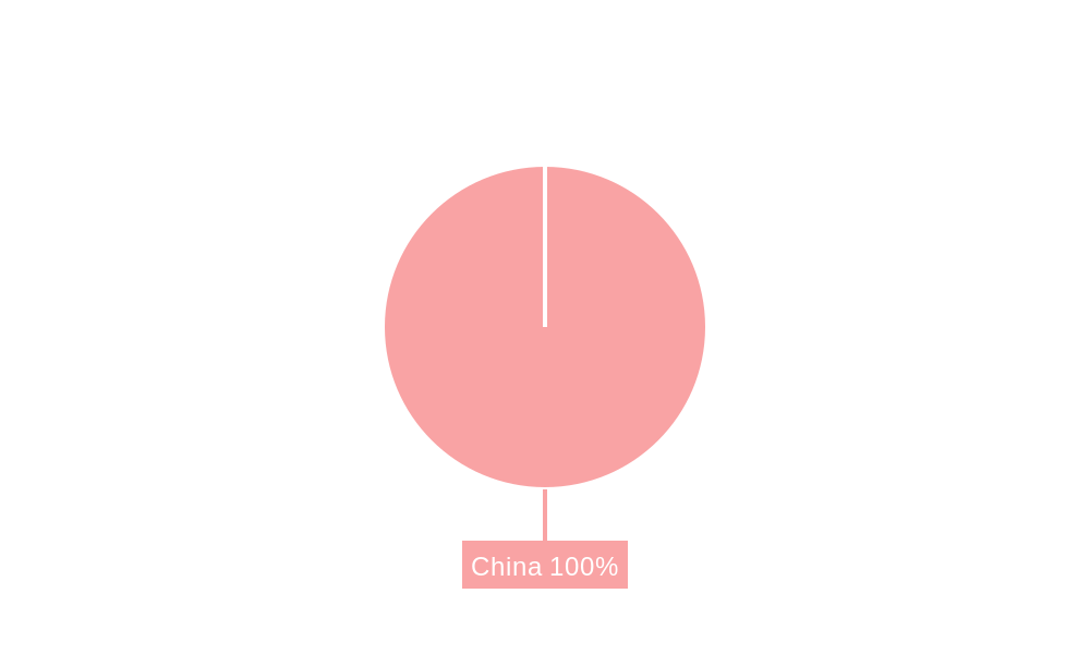
China Satellite Imagery Services Market Segmentation By Geography
- 1. China
China Satellite Imagery Services Market REPORT HIGHLIGHTS
| Aspects | Details |
|---|---|
| Study Period | 2019-2033 |
| Base Year | 2024 |
| Estimated Year | 2025 |
| Forecast Period | 2025-2033 |
| Historical Period | 2019-2024 |
| Growth Rate | CAGR of 13.20% from 2019-2033 |
| Segmentation |
|
Table of Contents
- 1. Introduction
- 1.1. Research Scope
- 1.2. Market Segmentation
- 1.3. Research Methodology
- 1.4. Definitions and Assumptions
- 2. Executive Summary
- 2.1. Introduction
- 3. Market Dynamics
- 3.1. Introduction
- 3.2. Market Drivers
- 3.2.1. The country's Investments in Space Technology and Defence; Adoption of Big Data and Imagery Analytics
- 3.3. Market Restrains
- 3.3.1. High Cost of Satellite Imaging Data Acquisition and Processing; High-resolution Images Offered by Other Imaging Technologies
- 3.4. Market Trends
- 3.4.1. The country's Investments in Space Technology and Defense Drives Market Growth.
- 4. Market Factor Analysis
- 4.1. Porters Five Forces
- 4.2. Supply/Value Chain
- 4.3. PESTEL analysis
- 4.4. Market Entropy
- 4.5. Patent/Trademark Analysis
- 5. China Satellite Imagery Services Market Analysis, Insights and Forecast, 2019-2031
- 5.1. Market Analysis, Insights and Forecast - by Application
- 5.1.1. Geospatial Data Acquisition and Mapping
- 5.1.2. Natural Resource Management
- 5.1.3. Surveillance and Security
- 5.1.4. Conservation and Research
- 5.1.5. Disaster Management
- 5.1.6. Intelligence
- 5.2. Market Analysis, Insights and Forecast - by End-User
- 5.2.1. Government
- 5.2.2. Construction
- 5.2.3. Transportation and Logistics
- 5.2.4. Military and Defense
- 5.2.5. Forestry and Agriculture
- 5.2.6. Other End-Users
- 5.3. Market Analysis, Insights and Forecast - by Region
- 5.3.1. China
- 5.1. Market Analysis, Insights and Forecast - by Application
- 6. Competitive Analysis
- 6.1. Market Share Analysis 2024
- 6.2. Company Profiles
- 6.2.1 21st Century Space Technology Application Co Ltd
- 6.2.1.1. Overview
- 6.2.1.2. Products
- 6.2.1.3. SWOT Analysis
- 6.2.1.4. Recent Developments
- 6.2.1.5. Financials (Based on Availability)
- 6.2.2 Airbus
- 6.2.2.1. Overview
- 6.2.2.2. Products
- 6.2.2.3. SWOT Analysis
- 6.2.2.4. Recent Developments
- 6.2.2.5. Financials (Based on Availability)
- 6.2.3 Beijing Space View Technology Co Ltd
- 6.2.3.1. Overview
- 6.2.3.2. Products
- 6.2.3.3. SWOT Analysis
- 6.2.3.4. Recent Developments
- 6.2.3.5. Financials (Based on Availability)
- 6.2.4 China Siwei Surveying and Mapping Technology Co LTD
- 6.2.4.1. Overview
- 6.2.4.2. Products
- 6.2.4.3. SWOT Analysis
- 6.2.4.4. Recent Developments
- 6.2.4.5. Financials (Based on Availability)
- 6.2.5 China National Space Administration
- 6.2.5.1. Overview
- 6.2.5.2. Products
- 6.2.5.3. SWOT Analysis
- 6.2.5.4. Recent Developments
- 6.2.5.5. Financials (Based on Availability)
- 6.2.6 Mapbox
- 6.2.6.1. Overview
- 6.2.6.2. Products
- 6.2.6.3. SWOT Analysis
- 6.2.6.4. Recent Developments
- 6.2.6.5. Financials (Based on Availability)
- 6.2.7 Beijing Zero Map Information Technology Co Ltd
- 6.2.7.1. Overview
- 6.2.7.2. Products
- 6.2.7.3. SWOT Analysis
- 6.2.7.4. Recent Developments
- 6.2.7.5. Financials (Based on Availability)
- 6.2.8 CHANG GUANG SATELLITE TECHNOLOGY CO LTD
- 6.2.8.1. Overview
- 6.2.8.2. Products
- 6.2.8.3. SWOT Analysis
- 6.2.8.4. Recent Developments
- 6.2.8.5. Financials (Based on Availability)
- 6.2.9 National Satellite Meteorological Center
- 6.2.9.1. Overview
- 6.2.9.2. Products
- 6.2.9.3. SWOT Analysis
- 6.2.9.4. Recent Developments
- 6.2.9.5. Financials (Based on Availability)
- 6.2.10 HEAD Aerospace Group
- 6.2.10.1. Overview
- 6.2.10.2. Products
- 6.2.10.3. SWOT Analysis
- 6.2.10.4. Recent Developments
- 6.2.10.5. Financials (Based on Availability)
- 6.2.1 21st Century Space Technology Application Co Ltd
List of Figures
- Figure 1: China Satellite Imagery Services Market Revenue Breakdown (Million, %) by Product 2024 & 2032
- Figure 2: China Satellite Imagery Services Market Share (%) by Company 2024
List of Tables
- Table 1: China Satellite Imagery Services Market Revenue Million Forecast, by Region 2019 & 2032
- Table 2: China Satellite Imagery Services Market Revenue Million Forecast, by Application 2019 & 2032
- Table 3: China Satellite Imagery Services Market Revenue Million Forecast, by End-User 2019 & 2032
- Table 4: China Satellite Imagery Services Market Revenue Million Forecast, by Region 2019 & 2032
- Table 5: China Satellite Imagery Services Market Revenue Million Forecast, by Country 2019 & 2032
- Table 6: China Satellite Imagery Services Market Revenue Million Forecast, by Application 2019 & 2032
- Table 7: China Satellite Imagery Services Market Revenue Million Forecast, by End-User 2019 & 2032
- Table 8: China Satellite Imagery Services Market Revenue Million Forecast, by Country 2019 & 2032
Frequently Asked Questions
1. What is the projected Compound Annual Growth Rate (CAGR) of the China Satellite Imagery Services Market ?
The projected CAGR is approximately 13.20%.
2. Which companies are prominent players in the China Satellite Imagery Services Market ?
Key companies in the market include 21st Century Space Technology Application Co Ltd, Airbus, Beijing Space View Technology Co Ltd, China Siwei Surveying and Mapping Technology Co LTD, China National Space Administration, Mapbox, Beijing Zero Map Information Technology Co Ltd, CHANG GUANG SATELLITE TECHNOLOGY CO LTD, National Satellite Meteorological Center, HEAD Aerospace Group.
3. What are the main segments of the China Satellite Imagery Services Market ?
The market segments include Application, End-User.
4. Can you provide details about the market size?
The market size is estimated to be USD XX Million as of 2022.
5. What are some drivers contributing to market growth?
The country's Investments in Space Technology and Defence; Adoption of Big Data and Imagery Analytics.
6. What are the notable trends driving market growth?
The country's Investments in Space Technology and Defense Drives Market Growth..
7. Are there any restraints impacting market growth?
High Cost of Satellite Imaging Data Acquisition and Processing; High-resolution Images Offered by Other Imaging Technologies.
8. Can you provide examples of recent developments in the market?
June 2023: The country awarded a contract to share satellite Imagery data with BRICS countries after the signing of an agreement on Cooperation on the BRICS Remote Sensing Satellite Constellation and shared 400 scenes of satellite imagery data with the BRICS countries, with the total volume amounting to 1.5 TB, which supports the growth of satellite imagery services market in China by creating a business opportunity for the Chinese vendors.
9. What pricing options are available for accessing the report?
Pricing options include single-user, multi-user, and enterprise licenses priced at USD 3800, USD 4500, and USD 5800 respectively.
10. Is the market size provided in terms of value or volume?
The market size is provided in terms of value, measured in Million.
11. Are there any specific market keywords associated with the report?
Yes, the market keyword associated with the report is "China Satellite Imagery Services Market ," which aids in identifying and referencing the specific market segment covered.
12. How do I determine which pricing option suits my needs best?
The pricing options vary based on user requirements and access needs. Individual users may opt for single-user licenses, while businesses requiring broader access may choose multi-user or enterprise licenses for cost-effective access to the report.
13. Are there any additional resources or data provided in the China Satellite Imagery Services Market report?
While the report offers comprehensive insights, it's advisable to review the specific contents or supplementary materials provided to ascertain if additional resources or data are available.
14. How can I stay updated on further developments or reports in the China Satellite Imagery Services Market ?
To stay informed about further developments, trends, and reports in the China Satellite Imagery Services Market , consider subscribing to industry newsletters, following relevant companies and organizations, or regularly checking reputable industry news sources and publications.
Methodology
Step 1 - Identification of Relevant Samples Size from Population Database


Step 2 - Approaches for Defining Global Market Size (Value, Volume* & Price*)

Note*: In applicable scenarios
Step 3 - Data Sources
Primary Research
- Web Analytics
- Survey Reports
- Research Institute
- Latest Research Reports
- Opinion Leaders
Secondary Research
- Annual Reports
- White Paper
- Latest Press Release
- Industry Association
- Paid Database
- Investor Presentations

Step 4 - Data Triangulation
Involves using different sources of information in order to increase the validity of a study
These sources are likely to be stakeholders in a program - participants, other researchers, program staff, other community members, and so on.
Then we put all data in single framework & apply various statistical tools to find out the dynamic on the market.
During the analysis stage, feedback from the stakeholder groups would be compared to determine areas of agreement as well as areas of divergence
